Beiguoyuan geodata
Beiguoyuan (Hebei) is a seat of a fourth-order administrative division; located in China in Asia/Shanghai (GMT+8) time zone. In our database, there are 1268 cities with bigger population. Compared to other cities in China, 82.3% of cities are located further ↓South; 50.5% of cities are located further ←West and 56% of cities have lower elevation than Beiguoyuan. Note1


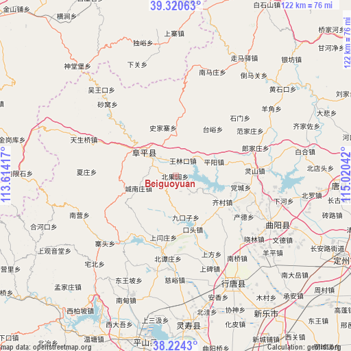
Beiguoyuan GPS coordinates[2]
38° 46' 28.452" North, 114° 19' 2.244" East
| Map corner | latitude | longitude |
|---|---|---|
| Upper-left | 39.32063°, | 113.61417° |
| Center: | 38.77457°, | 114.31729° |
| Lower-right: | 38.2243°, | 115.02042° |
| Map W x H: | 121.9×121.9 km | = 75.7×75.7mi |
| max Lat: | 53.31946° ⇑17.7% North |
| Beiguoyuan: | 38.77457° |
| min Lat: | ⇓82.3% South 18.22056° |
| min Long | Beiguoyuan | max Long |
| 75.07348° | 114.31729° | 134.28917° |
| W 50.5%⇐ | ⇒49.5% E |
Elevation
Elevation of Beiguoyuan is 216 m = 709 ft, and this is 268.8 m = 882 ft below average elevation for this country.
| Max E: |
5622 m = 18445 ft | 44% |
| Avg. | 484.8 m = 1591 ft | |
| Beiguoyuan | 216 m = 709 ft | |
Min E: |
-3 m = -10 ft | 56% |
See also: China elevation on elevation.city.
Geographical zone
Beiguoyuan is located in North temperate zone (between Tropic of Cancer and the Arctic Circle). Distance of this Northern Tropic circle is 1705.4 km =1059.7 mi to South.| Distance of | km | miles | from Beiguoyuan |
|---|---|---|---|
| North Pole | 5695.7 | 3539.1 | to North |
| Arctic Circle | 3089.8 | 1919.9 | to North |
| Tropic Cancer | 1705.4 | 1059.7 | to South |
| Equator | 4311.3 | 2678.9 | to South |


Nearby cities:
15 places around Beiguoyuan: (largest is in red/bold)
• Beihe
22.3 km =13.9 mi,  135°
135°
• Beitai
21.9 km =13.6 mi,  67°
67°
• Chande
27.3 km =17 mi,  121°
121°
• Chatou
24.8 km =15.4 mi,  196°
196°
• Chengnanzhuang
13.8 km =8.6 mi,  251°
251°
• Dangcheng
22.4 km =13.9 mi,  100°
100°
• Datai
23.5 km =14.6 mi,  11°
11°
• Jiukouzi
14.8 km =9.2 mi,  166°
166°
• Koutou
19.8 km =12.3 mi,  163°
163°
• Pingyang
14.1 km =8.8 mi, 70°
• Qicun
18.4 km =11.4 mi, 118°
• Shangyanzhuang
22 km =13.7 mi,  192°
192°
• Shijiazhai
17.2 km =10.7 mi,  345°
345°
• Taiyu
20.8 km =12.9 mi,  38°
38°
• Wanglinkou
5.7 km =3.5 mi,  22°
22°
Sources, notices
• [Note1] Compared only with cities in China existing in our database
• [Src1] Map data: © OpenStreetMap contributors (CC-BY-SA)
• [Src2] Other city data from geonames.org with taken over terms of usage.
• [Src3] Geographical zone / Annual Mean Temperature by Robert A. Rohde @ Wikipedia
