Wanglinkou geodata
Wanglinkou (Hebei) is a seat of a fourth-order administrative division; located in China in Asia/Shanghai (GMT+8) time zone. In our database, there are 1268 cities with bigger population. Compared to other cities in China, 82.3% of cities are located further ↓South; 50.6% of cities are located further ←West and 57.3% of cities have lower elevation than Wanglinkou. Note1


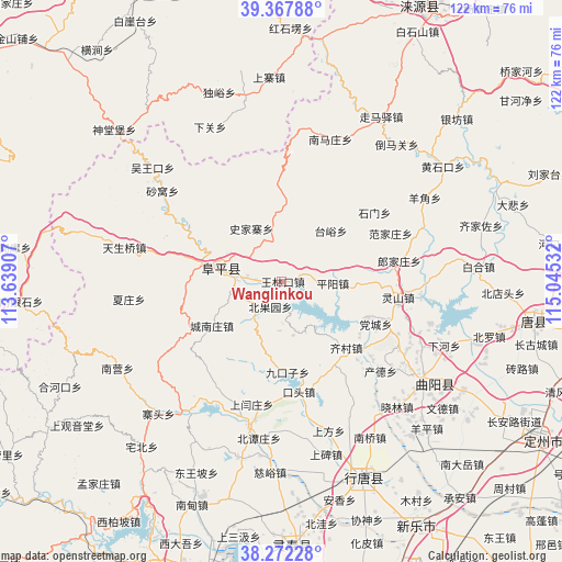
Wanglinkou GPS coordinates[2]
38° 49' 19.884" North, 114° 20' 31.884" East
| Map corner | latitude | longitude |
|---|---|---|
| Upper-left | 39.36788°, | 113.63907° |
| Center: | 38.82219°, | 114.34219° |
| Lower-right: | 38.27228°, | 115.04532° |
| Map W x H: | 121.8×121.8 km | = 75.7×75.7mi |
| max Lat: | 53.31946° ⇑17.7% North |
| Wanglinkou: | 38.82219° |
| min Lat: | ⇓82.3% South 18.22056° |
| min Long | Wanglinkou | max Long |
| 75.07348° | 114.34219° | 134.28917° |
| W 50.6%⇐ | ⇒49.4% E |
Elevation
Elevation of Wanglinkou is 228 m = 748 ft, and this is 256.8 m = 843 ft below average elevation for this country.
| Max E: |
5622 m = 18445 ft | 42.7% |
| Avg. | 484.8 m = 1591 ft | |
| Wanglinkou | 228 m = 748 ft | |
Min E: |
-3 m = -10 ft | 57.3% |
See also: China elevation on elevation.city.
Geographical zone
Wanglinkou is located in North temperate zone (between Tropic of Cancer and the Arctic Circle). Distance of this Northern Tropic circle is 1710.7 km =1063 mi to South.| Distance of | km | miles | from Wanglinkou |
|---|---|---|---|
| North Pole | 5690.4 | 3535.8 | to North |
| Arctic Circle | 3084.6 | 1916.7 | to North |
| Tropic Cancer | 1710.7 | 1063 | to South |
| Equator | 4316.6 | 2682.2 | to South |


Nearby cities:
15 places around Wanglinkou: (largest is in red/bold)
• Beiguoyuan
5.7 km =3.5 mi,  202°
202°
• Beihe
25.1 km =15.6 mi,  147°
147°
• Beitai
18.3 km =11.4 mi,  79°
79°
• Chengnanzhuang
18.1 km =11.2 mi,  237°
237°
• Dangcheng
22 km =13.7 mi,  115°
115°
• Datai
17.9 km =11.1 mi,  8°
8°
• Fanjiazhuang
25.4 km =15.8 mi,  66°
66°
• Jiukouzi
19.8 km =12.3 mi,  176°
176°
• Koutou
24.5 km =15.2 mi,  171°
171°
• Lingshan
25.6 km =15.9 mi,  98°
98°
• Pingyang
11.1 km =6.9 mi,  92°
92°
• Qicun
19.9 km =12.4 mi,  135°
135°
• Shijiazhai
13.1 km =8.1 mi,  329°
329°
• Shimen
24.9 km =15.5 mi,  53°
53°
• Taiyu
15.4 km =9.6 mi,  44°
44°
Sources, notices
• [Note1] Compared only with cities in China existing in our database
• [Src1] Map data: © OpenStreetMap contributors (CC-BY-SA)
• [Src2] Other city data from geonames.org with taken over terms of usage.
• [Src3] Geographical zone / Annual Mean Temperature by Robert A. Rohde @ Wikipedia
