Shanxia geodata
Shanxia (Fujian) is a seat of a fourth-order administrative division; located in China in Asia/Shanghai (GMT+8) time zone. In our database, there are 1268 cities with bigger population. Compared to other cities in China, 75.2% of cities are located further ↑North; 72% of cities are located further ←West and 69.7% of cities have lower elevation than Shanxia. Note1


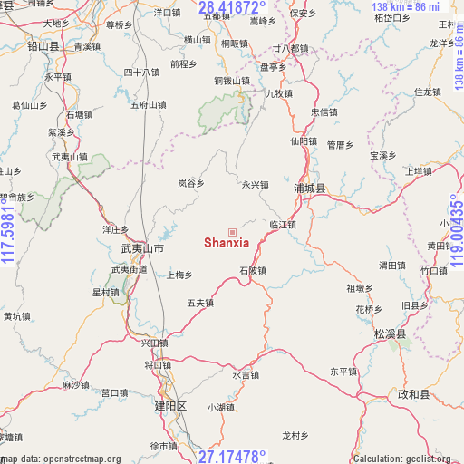
Shanxia GPS coordinates[2]
27° 47' 54.708" North, 118° 18' 4.392" East
| Map corner | latitude | longitude |
|---|---|---|
| Upper-left | 28.41872°, | 117.5981° |
| Center: | 27.79853°, | 118.30122° |
| Lower-right: | 27.17478°, | 119.00435° |
| Map W x H: | 138.3×138.3 km | = 85.9×85.9mi |
| max Lat: | 53.31946° ⇑75.2% North |
| Shanxia: | 27.79853° |
| min Lat: | ⇓24.8% South 18.22056° |
| min Long | Shanxia | max Long |
| 75.07348° | 118.30122° | 134.28917° |
| W 72%⇐ | ⇒28% E |
Elevation
Elevation of Shanxia is 405 m = 1329 ft, and this is 79.8 m = 262 ft below average elevation for this country.
| Max E: |
5622 m = 18445 ft | 30.3% |
| Avg. | 484.8 m = 1591 ft | |
| Shanxia | 405 m = 1329 ft | |
Min E: |
-3 m = -10 ft | 69.7% |
See also: China elevation on elevation.city.
Geographical zone
Shanxia is located in North temperate zone (between Tropic of Cancer and the Arctic Circle). Distance of this Northern Tropic circle is 485 km =301.4 mi to South.| Distance of | km | miles | from Shanxia |
|---|---|---|---|
| North Pole | 6916.2 | 4297.5 | to North |
| Arctic Circle | 4310.3 | 2678.3 | to North |
| Tropic Cancer | 485 | 301.4 | to South |
| Equator | 3090.9 | 1920.6 | to South |


Nearby cities:
15 places around Shanxia: (largest is in red/bold)
• Fuling
35.1 km =21.8 mi,  72°
72°
• Haocun
28.3 km =17.6 mi,  144°
144°
• Huilong
36.9 km =22.9 mi,  163°
163°
• Liantang
25.3 km =15.7 mi,  56°
56°
• Linjiang
15.4 km =9.6 mi,  79°
79°
• Pucheng
26.7 km =16.6 mi, 58°
• Shibei
12.6 km =7.8 mi,  152°
152°
• Shuibeijie
28.8 km =17.9 mi,  113°
113°
• Wan’an
28.1 km =17.5 mi, 62°
• Wufu
22.8 km =14.2 mi,  204°
204°
• Wuyishan
27 km =16.8 mi,  260°
260°
• Xianyang
34.8 km =21.6 mi,  37°
37°
• Xingtian
40.4 km =25.1 mi,  214°
214°
• Yongxing
16 km =9.9 mi,  24°
24°
• Zhangdun
39.3 km =24.4 mi, 155°
Sources, notices
• [Note1] Compared only with cities in China existing in our database
• [Src1] Map data: © OpenStreetMap contributors (CC-BY-SA)
• [Src2] Other city data from geonames.org with taken over terms of usage.
• [Src3] Geographical zone / Annual Mean Temperature by Robert A. Rohde @ Wikipedia
