Shataping geodata
Shataping (Hunan) is a seat of a fourth-order administrative division; located in China in Asia/Shanghai (GMT+8) time zone. In our database, there are 1268 cities with bigger population. Compared to other cities in China, 58.7% of cities are located further ↑North; 71.1% of cities are located further →East and 68.3% of cities have lower elevation than Shataping. Note1


Shataping GPS coordinates[2]
29° 35' 18.816" North, 110° 2' 19.104" East
| Map corner | latitude | longitude |
|---|---|---|
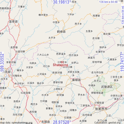
| Upper-left | 30.19813°, | 109.33552° |
| Center: | 29.58856°, | 110.03864° |
| Lower-right: | 28.97528°, | 110.74177° |
| Map W x H: | 136×136 km | = 84.5×84.5mi |
| max Lat: | 53.31946° ⇑58.7% North |
| Shataping: | 29.58856° |
| min Lat: | ⇓41.3% South 18.22056° |
| min Long | Shataping | max Long |
| 75.07348° | 110.03864° | 134.28917° |
| W 28.9%⇐ | ⇒71.1% E |
Elevation
Elevation of Shataping is 381 m = 1250 ft, and this is 103.8 m = 341 ft below average elevation for this country.
| Max E: |
5622 m = 18445 ft | 31.7% |
| Avg. | 484.8 m = 1591 ft | |
| Shataping | 381 m = 1250 ft | |
Min E: |
-3 m = -10 ft | 68.3% |
See also: China elevation on elevation.city.
Geographical zone
Shataping is located in North temperate zone (between Tropic of Cancer and the Arctic Circle). Distance of this Northern Tropic circle is 684 km =425 mi to South.| Distance of | km | miles | from Shataping |
|---|---|---|---|
| North Pole | 6717.1 | 4173.8 | to North |
| Arctic Circle | 4111.2 | 2554.6 | to North |
| Tropic Cancer | 684 | 425 | to South |
| Equator | 3289.9 | 2044.2 | to South |


Nearby cities:
15 places around Shataping: (largest is in red/bold)
• Bamaoxi
9.6 km =6 mi,  352°
352°
• Chenjiahe
12.9 km =8 mi,  207°
207°
• Guluoshan
14.8 km =9.2 mi,  90°
90°
• Hongjiaguan
17.5 km =10.9 mi,  134°
134°
• Jianjiapo
9 km =5.6 mi,  243°
243°
• Kuzhuping
7.9 km =4.9 mi,  34°
34°
• Lianghekou
15.2 km =9.4 mi,  184°
184°
• Liangshuikou
7.7 km =4.8 mi, 133°
• Longtanping
15.1 km =9.4 mi,  49°
49°
• Pailou
18.1 km =11.2 mi,  256°
256°
• Sifangxi
14.8 km =9.2 mi,  57°
57°
• Wangjiaping
17.6 km =10.9 mi,  316°
316°
• Xiaobutou
15.3 km =9.5 mi,  158°
158°
• Yanwukou
15.3 km =9.5 mi,  230°
230°
• Zhangjiaqiao
13.5 km =8.4 mi, 132°
Sources, notices
• [Note1] Compared only with cities in China existing in our database
• [Src1] Map data: © OpenStreetMap contributors (CC-BY-SA)
• [Src2] Other city data from geonames.org with taken over terms of usage.
• [Src3] Geographical zone / Annual Mean Temperature by Robert A. Rohde @ Wikipedia
