Taohua geodata
Taohua (Hebei) is a seat of a fourth-order administrative division; located in China in Asia/Shanghai (GMT+8) time zone. In our database, there are 1268 cities with bigger population. Compared to other cities in China, 86.6% of cities are located further ↓South; 54.4% of cities are located further ←West and 85.8% of cities have lower elevation than Taohua. Note1


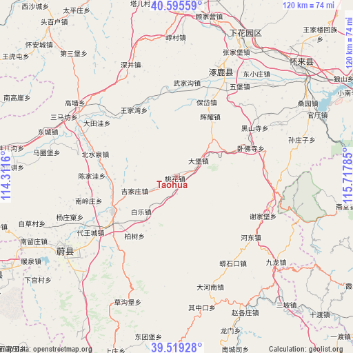
Taohua GPS coordinates[2]
40° 3' 34.416" North, 115° 0' 52.992" East
| Map corner | latitude | longitude |
|---|---|---|
| Upper-left | 40.59559°, | 114.3116° |
| Center: | 40.05956°, | 115.01472° |
| Lower-right: | 39.51928°, | 115.71785° |
| Map W x H: | 119.7×119.7 km | = 74.4×74.4mi |
| max Lat: | 53.31946° ⇑13.4% North |
| Taohua: | 40.05956° |
| min Lat: | ⇓86.6% South 18.22056° |
| min Long | Taohua | max Long |
| 75.07348° | 115.01472° | 134.28917° |
| W 54.4%⇐ | ⇒45.6% E |
Elevation
Elevation of Taohua is 1031 m = 3383 ft, and this is 546.2 m = 1792 ft above average elevation for this country.
| Max E: |
5622 m = 18445 ft | 14.2% |
| Taohua | 1031 m 3383 ft | |
| Avg. | 484.8 m = 1591 ft | |
Min E: |
-3 m = -10 ft | 85.8% |
See also: China elevation on elevation.city.
Geographical zone
Taohua is located in North temperate zone (between Tropic of Cancer and the Arctic Circle). Distance of this Northern Tropic circle is 1848.3 km =1148.5 mi to South.| Distance of | km | miles | from Taohua |
|---|---|---|---|
| North Pole | 5552.9 | 3450.4 | to North |
| Arctic Circle | 2947 | 1831.2 | to North |
| Tropic Cancer | 1848.3 | 1148.5 | to South |
| Equator | 4454.2 | 2767.7 | to South |


Nearby cities:
15 places around Taohua: (largest is in red/bold)
• Chengzhen
51.4 km =31.9 mi,  24°
24°
• Da’anshan
67.9 km =42.2 mi,  106°
106°
• Puwa
57 km =35.4 mi,  128°
128°
• Qingshui
52.7 km =32.7 mi,  104°
104°
• Shacheng
56 km =34.8 mi,  48°
48°
• Shidu
67.3 km =41.8 mi, 133°
• Shijiaying
59.7 km =37.1 mi, 112°
• Xiayunling
72 km =44.7 mi,  121°
121°
• Xibali
52.1 km =32.4 mi,  32°
32°
• Xicheng
73 km =45.4 mi,  274°
274°
• Yanchi
69.3 km =43.1 mi,  94°
94°
• Yanjiatai
47.1 km =29.3 mi, 97°
• Zhaitang
58.4 km =36.3 mi, 99°
• Zhangjiakou Shi Xuanhua Qu
61.3 km =38.1 mi,  2°
2°
• Zhuolu
38.5 km =23.9 mi, 26°
Sources, notices
• [Note1] Compared only with cities in China existing in our database
• [Src1] Map data: © OpenStreetMap contributors (CC-BY-SA)
• [Src2] Other city data from geonames.org with taken over terms of usage.
• [Src3] Geographical zone / Annual Mean Temperature by Robert A. Rohde @ Wikipedia
