Xianghai geodata
Xianghai (Jilin) is a seat of a fourth-order administrative division; located in China in Asia/Shanghai (GMT+8) time zone. In our database, there are 1268 cities with bigger population. Compared to other cities in China, 93.9% of cities are located further ↓South; 91.8% of cities are located further ←West and 50.2% of cities have higher elevation than Xianghai. Note1


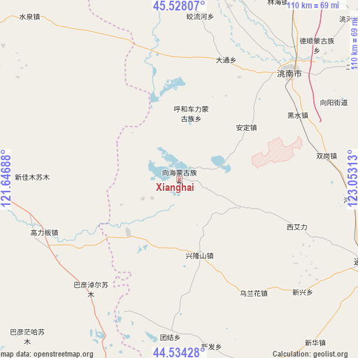
Xianghai GPS coordinates[2]
45° 1' 59.988" North, 122° 21' 0" East
| Map corner | latitude | longitude |
|---|---|---|
| Upper-left | 45.52807°, | 121.64688° |
| Center: | 45.03333°, | 122.35° |
| Lower-right: | 44.53428°, | 123.05313° |
| Map W x H: | 110.5×110.5 km | = 68.7×68.7mi |
| max Lat: | 53.31946° ⇑6.1% North |
| Xianghai: | 45.03333° |
| min Lat: | ⇓93.9% South 18.22056° |
| min Long | Xianghai | max Long |
| 75.07348° | 122.35° | 134.28917° |
| W 91.8%⇐ | ⇒8.2% E |
Elevation
Elevation of Xianghai is 163 m = 535 ft, and this is 321.8 m = 1056 ft below average elevation for this country.
| Max E: |
5622 m = 18445 ft | 50.2% |
| Avg. | 484.8 m = 1591 ft | |
| Xianghai | 163 m = 535 ft | |
Min E: |
-3 m = -10 ft | 49.8% |
See also: China elevation on elevation.city.
Geographical zone
Xianghai is located in North temperate zone (between Tropic of Cancer and the Arctic Circle). Distance of this North polar circle is 2393.9 km =1487.5 mi to North.| Distance of | km | miles | from Xianghai |
|---|---|---|---|
| North Pole | 4999.8 | 3106.7 | to North |
| Arctic Circle | 2393.9 | 1487.5 | to North |
| Tropic Cancer | 2401.3 | 1492.1 | to South |
| Equator | 5007.2 | 3111.3 | to South |


Nearby cities:
15 places around Xianghai: (largest is in red/bold)
• Anding
24.6 km =15.3 mi,  52°
52°
• Deshun
58.9 km =36.6 mi,  44°
44°
• Gaoliban
46.4 km =28.8 mi,  248°
248°
• Guangming
47.6 km =29.6 mi, 45°
• Heishui
41 km =25.5 mi,  63°
63°
• Kaitong
67.6 km =42 mi,  111°
111°
• Linhai
62.6 km =38.9 mi,  30°
30°
• Mingren
72.2 km =44.9 mi, 30°
• Shuanggang
45.8 km =28.5 mi,  79°
79°
• Shuiquan
66.3 km =41.2 mi,  320°
320°
• Taodong
61.3 km =38.1 mi,  14°
14°
• Tuquan
71.4 km =44.4 mi,  305°
305°
• Xi Ail
38.4 km =23.9 mi, 112°
• Xinfa
50.7 km =31.5 mi,  171°
171°
• Xinhua
64.5 km =40.1 mi,  140°
140°
Sources, notices
• [Note1] Compared only with cities in China existing in our database
• [Src1] Map data: © OpenStreetMap contributors (CC-BY-SA)
• [Src2] Other city data from geonames.org with taken over terms of usage.
• [Src3] Geographical zone / Annual Mean Temperature by Robert A. Rohde @ Wikipedia
