Kaitong geodata
Kaitong (Jilin) is a seat of a third-order administrative division; located in China in Asia/Shanghai (GMT+8) time zone. With population of 62,537 people, there are 687 cities with bigger population in this country. Compared to other cities in China, 93.7% of cities are located further ↓South; 92.8% of cities are located further ←West and 52.7% of cities have higher elevation than Kaitong. Note1


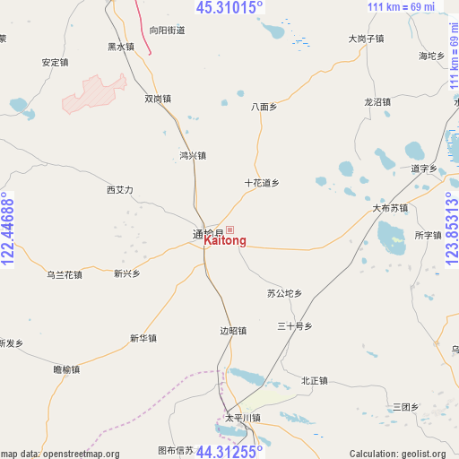
Kaitong GPS coordinates[2]
44° 48' 48.636" North, 123° 9' 0" East
| Map corner | latitude | longitude |
|---|---|---|
| Upper-left | 45.31015°, | 122.44688° |
| Center: | 44.81351°, | 123.15° |
| Lower-right: | 44.31255°, | 123.85313° |
| Map W x H: | 110.9×110.9 km | = 68.9×68.9mi |
| max Lat: | 53.31946° ⇑6.3% North |
| Kaitong: | 44.81351° |
| min Lat: | ⇓93.7% South 18.22056° |
| min Long | Kaitong | max Long |
| 75.07348° | 123.15° | 134.28917° |
| W 92.8%⇐ | ⇒7.2% E |
Elevation
Elevation of Kaitong is 145 m = 476 ft, and this is 339.8 m = 1115 ft below average elevation for this country.
| Max E: |
5622 m = 18445 ft | 52.7% |
| Avg. | 484.8 m = 1591 ft | |
| Kaitong | 145 m = 476 ft | |
Min E: |
-3 m = -10 ft | 47.3% |
See also: Kaitong elevation on elevation.city.
Geographical zone
Kaitong is located in North temperate zone (between Tropic of Cancer and the Arctic Circle). Distance of this Northern Tropic circle is 2376.9 km =1476.9 mi to South.| Distance of | km | miles | from Kaitong |
|---|---|---|---|
| North Pole | 5024.3 | 3122 | to North |
| Arctic Circle | 2418.4 | 1502.7 | to North |
| Tropic Cancer | 2376.9 | 1476.9 | to South |
| Equator | 4982.8 | 3096.2 | to South |


Nearby cities:
15 places around Kaitong: (largest is in red/bold)
• Anding
58.4 km =36.3 mi,  312°
312°
• Baokang
78.1 km =48.5 mi,  170°
170°
• Bor Ondor
85 km =52.8 mi,  224°
224°
• Changling
90.9 km =56.5 mi,  132°
132°
• Deshun
70.1 km =43.6 mi,  342°
342°
• Guangming
64.6 km =40.1 mi,  333°
333°
• Heishui
50.3 km =31.3 mi, 328°
• Linhai
84.4 km =52.4 mi, 338°
• Mingren
90.5 km =56.2 mi, 343°
• Qian’an
74.3 km =46.2 mi,  74°
74°
• Shuanggang
37.1 km =23.1 mi, 331°
• Xi Ail
29.2 km =18.1 mi,  289°
289°
• Xianghai
67.6 km =42 mi, 291°
• Xinfa
61 km =37.9 mi,  245°
245°
• Xinhua
34 km =21.1 mi, 221°
In other languages:
- In Chinese: T’ung-yü, K’ai-t’ung-hsien, Ch’i-ching-tzu, Ch’i-ching-tsa, K’ai-t’ung-chen, K’ai-t’ung, 开通
Sources, notices
• [Note1] Compared only with cities in China existing in our database
• [Src1] Map data: © OpenStreetMap contributors (CC-BY-SA)
• [Src2] Other city data from geonames.org with taken over terms of usage.
• [Src3] Geographical zone / Annual Mean Temperature by Robert A. Rohde @ Wikipedia
