Tahe geodata
Tahe (Heilongjiang) is a populated place; located in China in Asia/Shanghai (GMT+8) time zone. With population of 60,874 people, there are 719 cities with bigger population in this country. Compared to other cities in China, 100% of cities are located further ↓South; 94.5% of cities are located further ←West and 71.1% of cities have lower elevation than Tahe. Note1


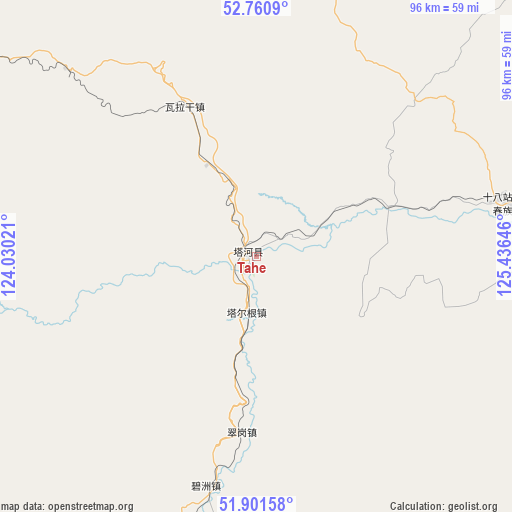
Tahe GPS coordinates[2]
52° 19' 59.988" North, 124° 43' 59.988" East
| Map corner | latitude | longitude |
|---|---|---|
| Upper-left | 52.7609°, | 124.03021° |
| Center: | 52.33333°, | 124.73333° |
| Lower-right: | 51.90158°, | 125.43646° |
| Map W x H: | 95.5×95.5 km | = 59.3×59.3mi |
| max Lat: | 53.31946° ⇑0% North |
| Tahe: | 52.33333° |
| min Lat: | ⇓100% South 18.22056° |
| min Long | Tahe | max Long |
| 75.07348° | 124.73333° | 134.28917° |
| W 94.5%⇐ | ⇒5.5% E |
Elevation
Elevation of Tahe is 432 m = 1417 ft, and this is 52.8 m = 173 ft below average elevation for this country.
| Max E: |
5622 m = 18445 ft | 28.9% |
| Avg. | 484.8 m = 1591 ft | |
| Tahe | 432 m = 1417 ft | |
Min E: |
-3 m = -10 ft | 71.1% |
See also: Tahe elevation on elevation.city.
Geographical zone
Tahe is located in North temperate zone (between Tropic of Cancer and the Arctic Circle). Distance of this North polar circle is 1582.3 km =983.2 mi to North.| Distance of | km | miles | from Tahe |
|---|---|---|---|
| North Pole | 4188.1 | 2602.4 | to North |
| Arctic Circle | 1582.3 | 983.2 | to North |
| Tropic Cancer | 3213 | 1996.5 | to South |
| Equator | 5818.9 | 3615.7 | to South |


Nearby cities:
15 places around Tahe: (largest is in red/bold)
• Baiyinna
79.7 km =49.5 mi,  83°
83°
• Bishui
76.1 km =47.3 mi,  252°
252°
• Bizhou
44.4 km =27.6 mi,  192°
192°
• Cangshan
98.8 km =61.4 mi,  232°
232°
• Cuigang
32.6 km =20.3 mi,  184°
184°
• Dawusu
61.1 km =38 mi, 193°
• Hanjiayuan
74.3 km =46.2 mi,  113°
113°
• Hongtu
88.5 km =55 mi,  206°
206°
• Hongwei
83.7 km =52 mi,  241°
241°
• Huyuan
102.7 km =63.8 mi, 231°
• Linhai
85.9 km =53.4 mi,  197°
197°
• Oupu
102.5 km =63.7 mi,  60°
60°
• Targen
10.5 km =6.5 mi, 189°
• Xinghua
90.2 km =56 mi,  104°
104°
• Xinlin
75.6 km =47 mi, 201°
Sources, notices
• [Note1] Compared only with cities in China existing in our database
• [Src1] Map data: © OpenStreetMap contributors (CC-BY-SA)
• [Src2] Other city data from geonames.org with taken over terms of usage.
• [Src3] Geographical zone / Annual Mean Temperature by Robert A. Rohde @ Wikipedia
