Cangshan geodata
Cangshan (Heilongjiang) is a seat of a fourth-order administrative division; located in China in Asia/Shanghai (GMT+8) time zone. In our database, there are 1268 cities with bigger population. Compared to other cities in China, 99.9% of cities are located further ↓South; 93.3% of cities are located further ←West and 77.6% of cities have lower elevation than Cangshan. Note1


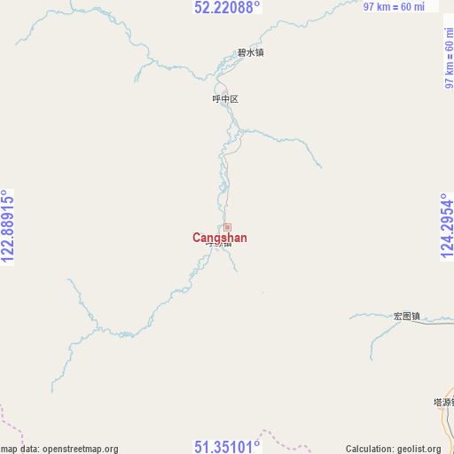
Cangshan GPS coordinates[2]
51° 47' 16.944" North, 123° 35' 32.172" East
| Map corner | latitude | longitude |
|---|---|---|
| Upper-left | 52.22088°, | 122.88915° |
| Center: | 51.78804°, | 123.59227° |
| Lower-right: | 51.35101°, | 124.2954° |
| Map W x H: | 96.7×96.7 km | = 60.1×60.1mi |
| max Lat: | 53.31946° ⇑0.1% North |
| Cangshan: | 51.78804° |
| min Lat: | ⇓99.9% South 18.22056° |
| min Long | Cangshan | max Long |
| 75.07348° | 123.59227° | 134.28917° |
| W 93.3%⇐ | ⇒6.7% E |
Elevation
Elevation of Cangshan is 594 m = 1949 ft, and this is 109.2 m = 358 ft above average elevation for this country.
| Max E: |
5622 m = 18445 ft | 22.4% |
| Cangshan | 594 m 1949 ft | |
| Avg. | 484.8 m = 1591 ft | |
Min E: |
-3 m = -10 ft | 77.6% |
See also: China elevation on elevation.city.
Geographical zone
Cangshan is located in North temperate zone (between Tropic of Cancer and the Arctic Circle). Distance of this North polar circle is 1642.9 km =1020.9 mi to North.| Distance of | km | miles | from Cangshan |
|---|---|---|---|
| North Pole | 4248.8 | 2640.1 | to North |
| Arctic Circle | 1642.9 | 1020.9 | to North |
| Tropic Cancer | 3152.4 | 1958.8 | to South |
| Equator | 5758.3 | 3578 | to South |


Nearby cities:
15 places around Cangshan: (largest is in red/bold)
• Bishui
37.8 km =23.5 mi,  7°
7°
• Bizhou
71.1 km =44.2 mi,  75°
75°
• Cuigang
80.7 km =50.1 mi,  69°
69°
• Dawusu
63.7 km =39.6 mi,  88°
88°
• Dayangqi
94 km =58.4 mi,  158°
158°
• Hongtu
42.4 km =26.3 mi,  115°
115°
• Hongwei
21.4 km =13.3 mi, 11°
• Huyuan
4.4 km =2.7 mi,  204°
204°
• Jinsong
89.7 km =55.7 mi,  152°
152°
• Linhai
56.5 km =35.1 mi,  112°
112°
• Tahe
98.8 km =61.4 mi,  52°
52°
• Targen
91.4 km =56.8 mi,  56°
56°
• Tayuan
59.7 km =37.1 mi,  128°
128°
• Xinlin
51.9 km =32.2 mi,  100°
100°
• Xintian
77.7 km =48.3 mi, 146°
Sources, notices
• [Note1] Compared only with cities in China existing in our database
• [Src1] Map data: © OpenStreetMap contributors (CC-BY-SA)
• [Src2] Other city data from geonames.org with taken over terms of usage.
• [Src3] Geographical zone / Annual Mean Temperature by Robert A. Rohde @ Wikipedia
