Pingzhuang geodata
Pingzhuang (Inner Mongolia) is a seat of a third-order administrative division; located in China in Asia/Shanghai (GMT+8) time zone. With population of 67,273 people, there are 639 cities with bigger population in this country. Compared to other cities in China, 91% of cities are located further ↓South; 77.5% of cities are located further ←West and 74.6% of cities have lower elevation than Pingzhuang. Note1


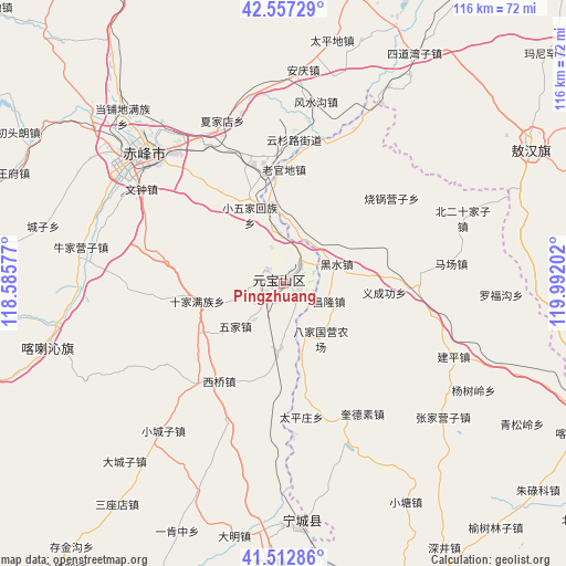
Pingzhuang GPS coordinates[2]
42° 2' 13.992" North, 119° 17' 20.004" East
| Map corner | latitude | longitude |
|---|---|---|
| Upper-left | 42.55729°, | 118.58577° |
| Center: | 42.03722°, | 119.28889° |
| Lower-right: | 41.51286°, | 119.99202° |
| Map W x H: | 116.1×116.1 km | = 72.1×72.1mi |
| max Lat: | 53.31946° ⇑9% North |
| Pingzhuang: | 42.03722° |
| min Lat: | ⇓91% South 18.22056° |
| min Long | Pingzhuang | max Long |
| 75.07348° | 119.28889° | 134.28917° |
| W 77.5%⇐ | ⇒22.5% E |
Elevation
Elevation of Pingzhuang is 514 m = 1686 ft, and this is 29.2 m = 96 ft above average elevation for this country.
| Max E: |
5622 m = 18445 ft | 25.4% |
| Pingzhuang | 514 m 1686 ft | |
| Avg. | 484.8 m = 1591 ft | |
Min E: |
-3 m = -10 ft | 74.6% |
See also: Pingzhuang elevation on elevation.city.
Geographical zone
Pingzhuang is located in North temperate zone (between Tropic of Cancer and the Arctic Circle). Distance of this Northern Tropic circle is 2068.2 km =1285.1 mi to South.| Distance of | km | miles | from Pingzhuang |
|---|---|---|---|
| North Pole | 5333 | 3313.8 | to North |
| Arctic Circle | 2727.1 | 1694.5 | to North |
| Tropic Cancer | 2068.2 | 1285.1 | to South |
| Equator | 4674.1 | 2904.4 | to South |


Nearby cities:
15 places around Pingzhuang: (largest is in red/bold)
• Beisijia
115.3 km =71.6 mi,  83°
83°
• Chaoyang
110 km =68.4 mi,  118°
118°
• Chifeng
37.1 km =23.1 mi,  313°
313°
• Jinshan
53.2 km =33.1 mi,  255°
255°
• Lingyuan
89.1 km =55.4 mi,  173°
173°
• Loujiadian
114.2 km =71 mi,  88°
88°
• Miaodong
85 km =52.8 mi, 171°
• Mujiayingzi
42.6 km =26.5 mi,  281°
281°
• Nanjie
115 km =71.5 mi,  189°
189°
• Pingquan
125.6 km =78 mi,  203°
203°
• Tianyi
52.4 km =32.6 mi,  175°
175°
• Wudan
102.1 km =63.4 mi,  347°
347°
• Xiawa
119.6 km =74.3 mi,  59°
59°
• Xinhui
57.2 km =35.5 mi, 61°
• Yebaishou
76.9 km =47.8 mi,  157°
157°
Sources, notices
• [Note1] Compared only with cities in China existing in our database
• [Src1] Map data: © OpenStreetMap contributors (CC-BY-SA)
• [Src2] Other city data from geonames.org with taken over terms of usage.
• [Src3] Geographical zone / Annual Mean Temperature by Robert A. Rohde @ Wikipedia
