Lingyuan geodata
Lingyuan (Liaoning) is a populated place; located in China in Asia/Shanghai (GMT+8) time zone. With population of 91,418 people, there are 463 cities with bigger population in this country. Compared to other cities in China, 89.6% of cities are located further ↓South; 78.2% of cities are located further ←West and 69.1% of cities have lower elevation than Lingyuan. Note1


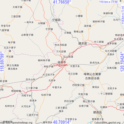
Lingyuan GPS coordinates[2]
41° 14' 24" North, 119° 24' 3.996" East
| Map corner | latitude | longitude |
|---|---|---|
| Upper-left | 41.76658°, | 118.69799° |
| Center: | 41.24°, | 119.40111° |
| Lower-right: | 40.70914°, | 120.10424° |
| Map W x H: | 117.6×117.6 km | = 73.1×73.1mi |
| max Lat: | 53.31946° ⇑10.4% North |
| Lingyuan: | 41.24° |
| min Lat: | ⇓89.6% South 18.22056° |
| min Long | Lingyuan | max Long |
| 75.07348° | 119.40111° | 134.28917° |
| W 78.2%⇐ | ⇒21.8% E |
Elevation
Elevation of Lingyuan is 394 m = 1293 ft, and this is 90.8 m = 298 ft below average elevation for this country.
| Max E: |
5622 m = 18445 ft | 30.9% |
| Avg. | 484.8 m = 1591 ft | |
| Lingyuan | 394 m = 1293 ft | |
Min E: |
-3 m = -10 ft | 69.1% |
See also: Lingyuan elevation on elevation.city.
Geographical zone
Lingyuan is located in North temperate zone (between Tropic of Cancer and the Arctic Circle). Distance of this Northern Tropic circle is 1979.5 km =1230 mi to South.| Distance of | km | miles | from Lingyuan |
|---|---|---|---|
| North Pole | 5421.6 | 3368.8 | to North |
| Arctic Circle | 2815.7 | 1749.6 | to North |
| Tropic Cancer | 1979.5 | 1230 | to South |
| Equator | 4585.5 | 2849.3 | to South |


Nearby cities:
15 places around Lingyuan: (largest is in red/bold)
• Baimashi
87.3 km =54.2 mi,  114°
114°
• Beiyingzi
58.4 km =36.3 mi,  204°
204°
• Chaoyang
95.5 km =59.3 mi,  67°
67°
• Dongshangen
101.1 km =62.8 mi,  162°
162°
• Guangyudian
98.3 km =61.1 mi,  150°
150°
• Guzhuyingzi
80 km =49.7 mi, 114°
• Jinshan
96.9 km =60.2 mi,  320°
320°
• Miaodong
5.4 km =3.4 mi,  32°
32°
• Nanjie
38.3 km =23.8 mi,  229°
229°
• Pingquan
65.6 km =40.8 mi,  246°
246°
• Pingzhuang
89.1 km =55.4 mi,  353°
353°
• Qinglong
100.4 km =62.4 mi, 202°
• Tianyi
36.8 km =22.9 mi, 351°
• Xintaimen
96.4 km =59.9 mi,  117°
117°
• Yebaishou
26.6 km =16.5 mi,  48°
48°
Sources, notices
• [Note1] Compared only with cities in China existing in our database
• [Src1] Map data: © OpenStreetMap contributors (CC-BY-SA)
• [Src2] Other city data from geonames.org with taken over terms of usage.
• [Src3] Geographical zone / Annual Mean Temperature by Robert A. Rohde @ Wikipedia
