Nanjie geodata
Nanjie (Liaoning) is a seat of a fourth-order administrative division; located in China in Asia/Shanghai (GMT+8) time zone. In our database, there are 1268 cities with bigger population. Compared to other cities in China, 89.2% of cities are located further ↓South; 76.3% of cities are located further ←West and 72.2% of cities have lower elevation than Nanjie. Note1


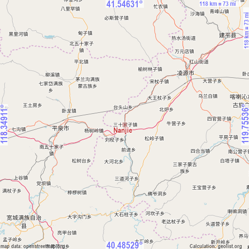
Nanjie GPS coordinates[2]
41° 1' 4.584" North, 119° 3' 8.028" East
| Map corner | latitude | longitude |
|---|---|---|
| Upper-left | 41.54631°, | 118.34911° |
| Center: | 41.01794°, | 119.05223° |
| Lower-right: | 40.48529°, | 119.75536° |
| Map W x H: | 118×118 km | = 73.3×73.3mi |
| max Lat: | 53.31946° ⇑10.8% North |
| Nanjie: | 41.01794° |
| min Lat: | ⇓89.2% South 18.22056° |
| min Long | Nanjie | max Long |
| 75.07348° | 119.05223° | 134.28917° |
| W 76.3%⇐ | ⇒23.7% E |
Elevation
Elevation of Nanjie is 457 m = 1499 ft, and this is 27.8 m = 91 ft below average elevation for this country.
| Max E: |
5622 m = 18445 ft | 27.8% |
| Avg. | 484.8 m = 1591 ft | |
| Nanjie | 457 m = 1499 ft | |
Min E: |
-3 m = -10 ft | 72.2% |
See also: China elevation on elevation.city.
Geographical zone
Nanjie is located in North temperate zone (between Tropic of Cancer and the Arctic Circle). Distance of this Northern Tropic circle is 1954.8 km =1214.7 mi to South.| Distance of | km | miles | from Nanjie |
|---|---|---|---|
| North Pole | 5446.3 | 3384.2 | to North |
| Arctic Circle | 2840.4 | 1764.9 | to North |
| Tropic Cancer | 1954.8 | 1214.7 | to South |
| Equator | 4560.8 | 2833.9 | to South |


Nearby cities:
15 places around Nanjie: (largest is in red/bold)
• Beiyingzi
29.1 km =18.1 mi,  169°
169°
• Chengde
92.1 km =57.2 mi,  265°
265°
• Dongshangen
93.7 km =58.2 mi,  139°
139°
• Guangyudian
98.9 km =61.5 mi,  127°
127°
• Guzhuyingzi
102.4 km =63.6 mi,  94°
94°
• Jiabeiyan
95.6 km =59.4 mi, 143°
• Kuancheng
66.3 km =41.2 mi,  226°
226°
• Lingyuan
38.3 km =23.8 mi,  49°
49°
• Miaodong
43.4 km =27 mi, 47°
• Mingshui
101.4 km =63 mi, 136°
• Pingquan
30.9 km =19.2 mi, 266°
• Qinglong
68.7 km =42.7 mi,  187°
187°
• Songling
104.2 km =64.7 mi,  219°
219°
• Tianyi
65.4 km =40.6 mi,  21°
21°
• Yebaishou
64.8 km =40.3 mi, 49°
Sources, notices
• [Note1] Compared only with cities in China existing in our database
• [Src1] Map data: © OpenStreetMap contributors (CC-BY-SA)
• [Src2] Other city data from geonames.org with taken over terms of usage.
• [Src3] Geographical zone / Annual Mean Temperature by Robert A. Rohde @ Wikipedia
