Mujiayingzi geodata
Mujiayingzi (Inner Mongolia) is a populated place; located in China in Asia/Shanghai (GMT+8) time zone. With population of 60,627 people, there are 723 cities with bigger population in this country. Compared to other cities in China, 91.1% of cities are located further ↓South; 74.9% of cities are located further ←West and 79.8% of cities have lower elevation than Mujiayingzi. Note1


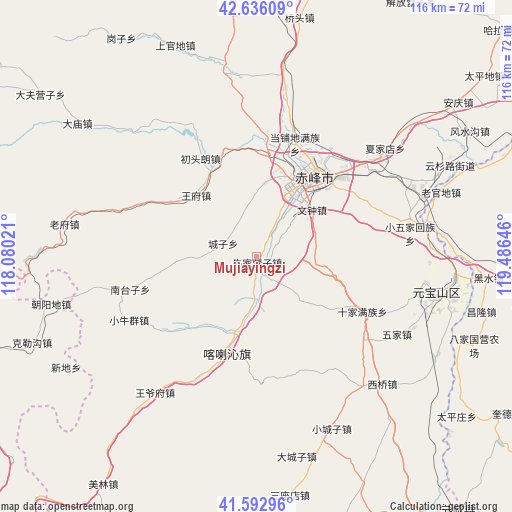
Mujiayingzi GPS coordinates[2]
42° 7' 0.012" North, 118° 46' 59.988" East
| Map corner | latitude | longitude |
|---|---|---|
| Upper-left | 42.63609°, | 118.08021° |
| Center: | 42.11667°, | 118.78333° |
| Lower-right: | 41.59296°, | 119.48646° |
| Map W x H: | 116×116 km | = 72.1×72.1mi |
| max Lat: | 53.31946° ⇑8.9% North |
| Mujiayingzi: | 42.11667° |
| min Lat: | ⇓91.1% South 18.22056° |
| min Long | Mujiayingzi | max Long |
| 75.07348° | 118.78333° | 134.28917° |
| W 74.9%⇐ | ⇒25.1% E |
Elevation
Elevation of Mujiayingzi is 687 m = 2254 ft, and this is 202.2 m = 663 ft above average elevation for this country.
| Max E: |
5622 m = 18445 ft | 20.2% |
| Mujiayingzi | 687 m 2254 ft | |
| Avg. | 484.8 m = 1591 ft | |
Min E: |
-3 m = -10 ft | 79.8% |
See also: Mujiayingzi elevation on elevation.city.
Geographical zone
Mujiayingzi is located in North temperate zone (between Tropic of Cancer and the Arctic Circle). Distance of this Northern Tropic circle is 2077 km =1290.6 mi to South.| Distance of | km | miles | from Mujiayingzi |
|---|---|---|---|
| North Pole | 5324.1 | 3308.2 | to North |
| Arctic Circle | 2718.2 | 1689 | to North |
| Tropic Cancer | 2077 | 1290.6 | to South |
| Equator | 4682.9 | 2909.8 | to South |


Nearby cities:
15 places around Mujiayingzi: (largest is in red/bold)
• Chaoyang
151.5 km =94.1 mi,  113°
113°
• Chengde
146.6 km =91.1 mi,  207°
207°
• Chifeng
22.5 km =14 mi,  41°
41°
• Jinshan
24.2 km =15 mi,  203°
203°
• Lingyuan
110.2 km =68.5 mi,  152°
152°
• Longhua
125.4 km =77.9 mi,  224°
224°
• Miaodong
107.6 km =66.9 mi, 149°
• Nanjie
124.2 km =77.2 mi,  169°
169°
• Pingquan
124.2 km =77.2 mi,  183°
183°
• Pingzhuang
42.6 km =26.5 mi,  101°
101°
• Tianyi
76.3 km =47.4 mi,  143°
143°
• Weichang
87.6 km =54.4 mi,  257°
257°
• Wudan
93 km =57.8 mi,  12°
12°
• Xinhui
93.7 km =58.2 mi,  78°
78°
• Yebaishou
107 km =66.5 mi, 138°
Sources, notices
• [Note1] Compared only with cities in China existing in our database
• [Src1] Map data: © OpenStreetMap contributors (CC-BY-SA)
• [Src2] Other city data from geonames.org with taken over terms of usage.
• [Src3] Geographical zone / Annual Mean Temperature by Robert A. Rohde @ Wikipedia
