Wudan geodata
Wudan (Inner Mongolia) is a seat of a third-order administrative division; located in China in Asia/Shanghai (GMT+8) time zone. In our database, there are 1268 cities with bigger population. Compared to other cities in China, 91.9% of cities are located further ↓South; 76.2% of cities are located further ←West and 78.5% of cities have lower elevation than Wudan. Note1


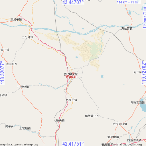
Wudan GPS coordinates[2]
42° 56' 3.984" North, 119° 1' 26.004" East
| Map corner | latitude | longitude |
|---|---|---|
| Upper-left | 43.44707°, | 118.32077° |
| Center: | 42.93444°, | 119.02389° |
| Lower-right: | 42.41751°, | 119.72702° |
| Map W x H: | 114.5×114.5 km | = 71.1×71.1mi |
| max Lat: | 53.31946° ⇑8.1% North |
| Wudan: | 42.93444° |
| min Lat: | ⇓91.9% South 18.22056° |
| min Long | Wudan | max Long |
| 75.07348° | 119.02389° | 134.28917° |
| W 76.2%⇐ | ⇒23.8% E |
Elevation
Elevation of Wudan is 633 m = 2077 ft, and this is 148.2 m = 486 ft above average elevation for this country.
| Max E: |
5622 m = 18445 ft | 21.5% |
| Wudan | 633 m 2077 ft | |
| Avg. | 484.8 m = 1591 ft | |
Min E: |
-3 m = -10 ft | 78.5% |
See also: China elevation on elevation.city.
Geographical zone
Wudan is located in North temperate zone (between Tropic of Cancer and the Arctic Circle). Distance of this Northern Tropic circle is 2167.9 km =1347.1 mi to South.| Distance of | km | miles | from Wudan |
|---|---|---|---|
| North Pole | 5233.2 | 3251.8 | to North |
| Arctic Circle | 2627.3 | 1632.5 | to North |
| Tropic Cancer | 2167.9 | 1347.1 | to South |
| Equator | 4773.9 | 2966.4 | to South |


Nearby cities:
15 places around Wudan: (largest is in red/bold)
• Baga Borihe
125.1 km =77.7 mi,  90°
90°
• Chifeng
74.2 km =46.1 mi,  183°
183°
• Daban
72.6 km =45.1 mi,  336°
336°
• Daqin Tal
134.5 km =83.6 mi, 92°
• Huanghuatala
146.3 km =90.9 mi,  102°
102°
• Jingpeng
127.3 km =79.1 mi,  285°
285°
• Jinshan
116.9 km =72.6 mi,  194°
194°
• Lindong
117.3 km =72.9 mi,  6°
6°
• Linxi
103.1 km =64.1 mi,  308°
308°
• Mujiayingzi
93 km =57.8 mi, 192°
• Pingzhuang
102.1 km =63.4 mi,  167°
167°
• Tianshan
136.7 km =84.9 mi,  39°
39°
• Xiawa
129.6 km =80.5 mi,  107°
107°
• Xinhui
101.7 km =63.2 mi,  135°
135°
• Yilongyong
136.5 km =84.8 mi, 103°
Sources, notices
• [Note1] Compared only with cities in China existing in our database
• [Src1] Map data: © OpenStreetMap contributors (CC-BY-SA)
• [Src2] Other city data from geonames.org with taken over terms of usage.
• [Src3] Geographical zone / Annual Mean Temperature by Robert A. Rohde @ Wikipedia
