Ming’antu geodata
Ming’antu (Inner Mongolia) is a seat of a third-order administrative division; located in China in Asia/Shanghai (GMT+8) time zone. In our database, there are 1268 cities with bigger population. Compared to other cities in China, 91.2% of cities are located further ↓South; 54.3% of cities are located further ←West and 89.8% of cities have lower elevation than Ming’antu. Note1


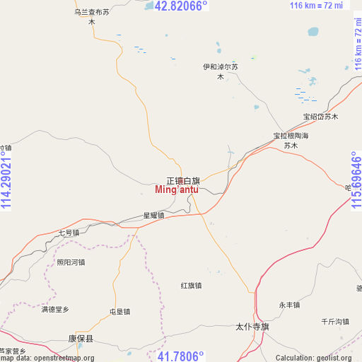
Ming’antu GPS coordinates[2]
42° 18' 10.008" North, 114° 59' 35.988" East
| Map corner | latitude | longitude |
|---|---|---|
| Upper-left | 42.82066°, | 114.29021° |
| Center: | 42.30278°, | 114.99333° |
| Lower-right: | 41.7806°, | 115.69646° |
| Map W x H: | 115.6×115.6 km | = 71.8×71.8mi |
| max Lat: | 53.31946° ⇑8.8% North |
| Ming’antu: | 42.30278° |
| min Lat: | ⇓91.2% South 18.22056° |
| min Long | Ming’antu | max Long |
| 75.07348° | 114.99333° | 134.28917° |
| W 54.3%⇐ | ⇒45.7% E |
Elevation
Elevation of Ming’antu is 1341 m = 4400 ft, and this is 856.2 m = 2809 ft above average elevation for this country.
| Max E: |
5622 m = 18445 ft | 10.2% |
| Ming’antu | 1341 m 4400 ft | |
| Avg. | 484.8 m = 1591 ft | |
Min E: |
-3 m = -10 ft | 89.8% |
See also: China elevation on elevation.city.
Geographical zone
Ming’antu is located in North temperate zone (between Tropic of Cancer and the Arctic Circle). Distance of this Northern Tropic circle is 2097.7 km =1303.4 mi to South.| Distance of | km | miles | from Ming’antu |
|---|---|---|---|
| North Pole | 5303.4 | 3295.4 | to North |
| Arctic Circle | 2697.5 | 1676.1 | to North |
| Tropic Cancer | 2097.7 | 1303.4 | to South |
| Equator | 4703.6 | 2922.7 | to South |


Nearby cities:
15 places around Ming’antu: (largest is in red/bold)
• Aguitu
164 km =101.9 mi,  249°
249°
• Baochang
52.1 km =32.4 mi,  153°
153°
• Changshun
94.4 km =58.7 mi,  241°
241°
• Duolun
123.8 km =76.9 mi,  95°
95°
• Hongge’ertu
166.5 km =103.5 mi, 246°
• Kangbao
59.6 km =37 mi,  211°
211°
• Nanhaoqian
161.9 km =100.6 mi, 211°
• Pingdingbu
91.7 km =57 mi,  140°
140°
• Qitai
146.9 km =91.3 mi, 235°
• Shangdu
83.7 km =52 mi,  94°
94°
• Tumu’ertai
161.1 km =100.1 mi, 251°
• Xin Bulag
95.5 km =59.3 mi,  265°
265°
• Xiwanzi
149.8 km =93.1 mi,  171°
171°
• Zhangbei
130.1 km =80.8 mi,  190°
190°
• Zhangjiakou
166.3 km =103.3 mi,  183°
183°
Sources, notices
• [Note1] Compared only with cities in China existing in our database
• [Src1] Map data: © OpenStreetMap contributors (CC-BY-SA)
• [Src2] Other city data from geonames.org with taken over terms of usage.
• [Src3] Geographical zone / Annual Mean Temperature by Robert A. Rohde @ Wikipedia
