Longhua geodata
Longhua (Hebei) is a seat of a third-order administrative division; located in China in Asia/Shanghai (GMT+8) time zone. In our database, there are 1268 cities with bigger population. Compared to other cities in China, 89.8% of cities are located further ↓South; 69.6% of cities are located further ←West and 76.3% of cities have lower elevation than Longhua. Note1


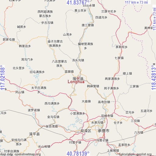
Longhua GPS coordinates[2]
41° 18' 42.012" North, 117° 43' 30" East
| Map corner | latitude | longitude |
|---|---|---|
| Upper-left | 41.83767°, | 117.02188° |
| Center: | 41.31167°, | 117.725° |
| Lower-right: | 40.78139°, | 118.42813° |
| Map W x H: | 117.4×117.4 km | = 72.9×72.9mi |
| max Lat: | 53.31946° ⇑10.2% North |
| Longhua: | 41.31167° |
| min Lat: | ⇓89.8% South 18.22056° |
| min Long | Longhua | max Long |
| 75.07348° | 117.725° | 134.28917° |
| W 69.6%⇐ | ⇒30.4% E |
Elevation
Elevation of Longhua is 553 m = 1814 ft, and this is 68.2 m = 224 ft above average elevation for this country.
| Max E: |
5622 m = 18445 ft | 23.7% |
| Longhua | 553 m 1814 ft | |
| Avg. | 484.8 m = 1591 ft | |
Min E: |
-3 m = -10 ft | 76.3% |
See also: China elevation on elevation.city.
Geographical zone
Longhua is located in North temperate zone (between Tropic of Cancer and the Arctic Circle). Distance of this Northern Tropic circle is 1987.5 km =1235 mi to South.| Distance of | km | miles | from Longhua |
|---|---|---|---|
| North Pole | 5413.6 | 3363.9 | to North |
| Arctic Circle | 2807.7 | 1744.6 | to North |
| Tropic Cancer | 1987.5 | 1235 | to South |
| Equator | 4593.4 | 2854.2 | to South |


Nearby cities:
15 places around Longhua: (largest is in red/bold)
• Beizhuang
100.9 km =62.7 mi,  207°
207°
• Changshaoying
100.5 km =62.4 mi,  235°
235°
• Chengde
44.5 km =27.7 mi,  153°
153°
• Dage
91.2 km =56.7 mi,  262°
262°
• Gaoling
94.5 km =58.7 mi, 213°
• Gubeikou
83.9 km =52.1 mi, 214°
• Kuancheng
101 km =62.8 mi,  140°
140°
• Luanping
57.4 km =35.7 mi,  220°
220°
• Pingquan
87.3 km =54.2 mi,  113°
113°
• Shuangtashan
40.9 km =25.4 mi,  171°
171°
• Taishitun
99.9 km =62.1 mi, 210°
• Weichang
70.4 km =43.7 mi,  1°
1°
• Xinchengzi
82.1 km =51 mi,  204°
204°
• Xinglong
100.8 km =62.6 mi,  190°
190°
• Yingshouyingzi
84.7 km =52.6 mi,  183°
183°
Sources, notices
• [Note1] Compared only with cities in China existing in our database
• [Src1] Map data: © OpenStreetMap contributors (CC-BY-SA)
• [Src2] Other city data from geonames.org with taken over terms of usage.
• [Src3] Geographical zone / Annual Mean Temperature by Robert A. Rohde @ Wikipedia
