Weichang geodata
Weichang (Hebei) is a seat of a third-order administrative division; located in China in Asia/Shanghai (GMT+8) time zone. In our database, there are 1268 cities with bigger population. Compared to other cities in China, 90.9% of cities are located further ↓South; 69.7% of cities are located further ←West and 83.5% of cities have lower elevation than Weichang. Note1


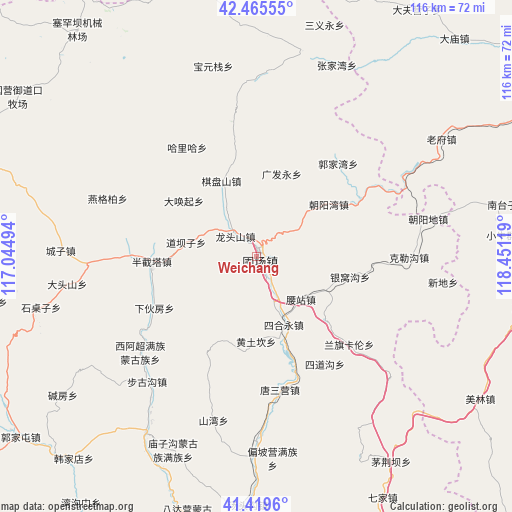
Weichang GPS coordinates[2]
41° 56' 40.992" North, 117° 44' 53.016" East
| Map corner | latitude | longitude |
|---|---|---|
| Upper-left | 42.46555°, | 117.04494° |
| Center: | 41.94472°, | 117.74806° |
| Lower-right: | 41.4196°, | 118.45119° |
| Map W x H: | 116.3×116.3 km | = 72.3×72.3mi |
| max Lat: | 53.31946° ⇑9.1% North |
| Weichang: | 41.94472° |
| min Lat: | ⇓90.9% South 18.22056° |
| min Long | Weichang | max Long |
| 75.07348° | 117.74806° | 134.28917° |
| W 69.7%⇐ | ⇒30.3% E |
Elevation
Elevation of Weichang is 887 m = 2910 ft, and this is 402.2 m = 1320 ft above average elevation for this country.
| Max E: |
5622 m = 18445 ft | 16.5% |
| Weichang | 887 m 2910 ft | |
| Avg. | 484.8 m = 1591 ft | |
Min E: |
-3 m = -10 ft | 83.5% |
See also: China elevation on elevation.city.
Geographical zone
Weichang is located in North temperate zone (between Tropic of Cancer and the Arctic Circle). Distance of this Northern Tropic circle is 2057.9 km =1278.7 mi to South.| Distance of | km | miles | from Weichang |
|---|---|---|---|
| North Pole | 5343.2 | 3320.1 | to North |
| Arctic Circle | 2737.4 | 1700.9 | to North |
| Tropic Cancer | 2057.9 | 1278.7 | to South |
| Equator | 4663.8 | 2898 | to South |


Nearby cities:
15 places around Weichang: (largest is in red/bold)
• Chengde
111.8 km =69.5 mi,  170°
170°
• Chifeng
106.5 km =66.2 mi,  70°
70°
• Dage
123.7 km =76.9 mi,  227°
227°
• Duolun
107.4 km =66.7 mi,  284°
284°
• Gubeikou
148 km =92 mi,  199°
199°
• Jingpeng
146.4 km =91 mi,  352°
352°
• Jinshan
76.1 km =47.3 mi,  92°
92°
• Longhua
70.4 km =43.7 mi,  181°
181°
• Luanping
120.7 km =75 mi, 198°
• Mujiayingzi
87.6 km =54.4 mi,  77°
77°
• Pingquan
130.6 km =81.2 mi,  143°
143°
• Pingzhuang
127.7 km =79.3 mi, 85°
• Shangdu
147.5 km =91.7 mi, 283°
• Shuangtashan
110.9 km =68.9 mi, 177°
• Tianyi
138 km =85.7 mi,  107°
107°
Sources, notices
• [Note1] Compared only with cities in China existing in our database
• [Src1] Map data: © OpenStreetMap contributors (CC-BY-SA)
• [Src2] Other city data from geonames.org with taken over terms of usage.
• [Src3] Geographical zone / Annual Mean Temperature by Robert A. Rohde @ Wikipedia
