Chengde geodata
Chengde (Hebei) is a populated place; located in China in Asia/Shanghai (GMT+8) time zone. With population of 449,325 people, there are 143 cities with bigger population in this country. Compared to other cities in China, 89.1% of cities are located further ↓South; 70.4% of cities are located further ←West and 64.5% of cities have lower elevation than Chengde. Note1


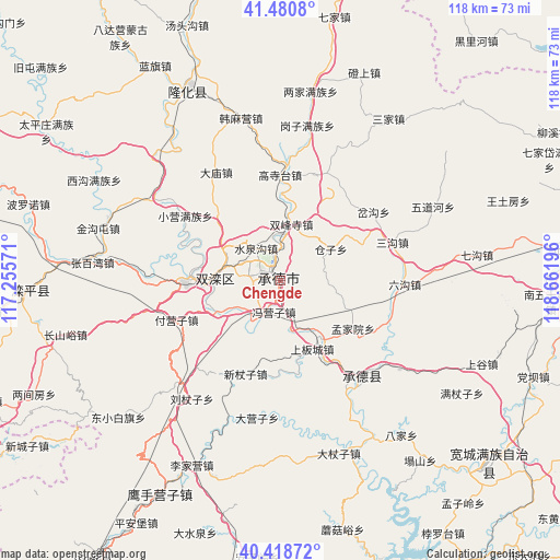
Chengde GPS coordinates[2]
40° 57' 6.84" North, 117° 57' 31.788" East
| Map corner | latitude | longitude |
|---|---|---|
| Upper-left | 41.4808°, | 117.25571° |
| Center: | 40.9519°, | 117.95883° |
| Lower-right: | 40.41872°, | 118.66196° |
| Map W x H: | 118.1×118.1 km | = 73.4×73.4mi |
| max Lat: | 53.31946° ⇑10.9% North |
| Chengde: | 40.9519° |
| min Lat: | ⇓89.1% South 18.22056° |
| min Long | Chengde | max Long |
| 75.07348° | 117.95883° | 134.28917° |
| W 70.4%⇐ | ⇒29.6% E |
Elevation
Elevation of Chengde is 318 m = 1043 ft, and this is 166.8 m = 547 ft below average elevation for this country.
| Max E: |
5622 m = 18445 ft | 35.5% |
| Avg. | 484.8 m = 1591 ft | |
| Chengde | 318 m = 1043 ft | |
Min E: |
-3 m = -10 ft | 64.5% |
See also: Chengde elevation on elevation.city.
Geographical zone
Chengde is located in North temperate zone (between Tropic of Cancer and the Arctic Circle). Distance of this Northern Tropic circle is 1947.5 km =1210.1 mi to South.| Distance of | km | miles | from Chengde |
|---|---|---|---|
| North Pole | 5453.6 | 3388.7 | to North |
| Arctic Circle | 2847.7 | 1769.5 | to North |
| Tropic Cancer | 1947.5 | 1210.1 | to South |
| Equator | 4553.4 | 2829.4 | to South |


Nearby cities:
15 places around Chengde: (largest is in red/bold)
• Beizhuang
82.9 km =51.5 mi,  233°
233°
• Gaoling
81.8 km =50.8 mi,  241°
241°
• Gubeikou
73.4 km =45.6 mi,  246°
246°
• Kuancheng
58.5 km =36.4 mi,  131°
131°
• Longhua
44.5 km =27.7 mi,  333°
333°
• Luanping
56.9 km =35.4 mi,  266°
266°
• Nanjie
92.1 km =57.2 mi,  85°
85°
• Pingquan
61.1 km =38 mi,  84°
84°
• Shuangtashan
13.8 km =8.6 mi, 268°
• Songling
77.8 km =48.3 mi,  160°
160°
• Taishitun
84.4 km =52.4 mi, 236°
• Xinchengzi
63.9 km =39.7 mi, 236°
• Xinglong
70.3 km =43.7 mi,  212°
212°
• Yingshouyingzi
51.1 km =31.8 mi, 209°
• Zunhua
85.9 km =53.4 mi,  180°
180°
Sources, notices
• [Note1] Compared only with cities in China existing in our database
• [Src1] Map data: © OpenStreetMap contributors (CC-BY-SA)
• [Src2] Other city data from geonames.org with taken over terms of usage.
• [Src3] Geographical zone / Annual Mean Temperature by Robert A. Rohde @ Wikipedia
