Kuancheng geodata
Kuancheng (Hebei) is a seat of a third-order administrative division; located in China in Asia/Shanghai (GMT+8) time zone. In our database, there are 1268 cities with bigger population. Compared to other cities in China, 88.3% of cities are located further ↓South; 73.1% of cities are located further ←West and 63.4% of cities have lower elevation than Kuancheng. Note1


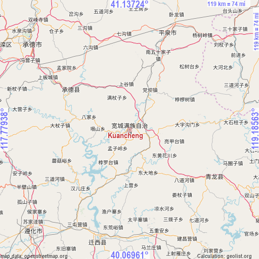
Kuancheng GPS coordinates[2]
40° 36' 20.016" North, 118° 28' 57" East
| Map corner | latitude | longitude |
|---|---|---|
| Upper-left | 41.13724°, | 117.77938° |
| Center: | 40.60556°, | 118.4825° |
| Lower-right: | 40.06961°, | 119.18563° |
| Map W x H: | 118.7×118.7 km | = 73.8×73.8mi |
| max Lat: | 53.31946° ⇑11.7% North |
| Kuancheng: | 40.60556° |
| min Lat: | ⇓88.3% South 18.22056° |
| min Long | Kuancheng | max Long |
| 75.07348° | 118.4825° | 134.28917° |
| W 73.1%⇐ | ⇒26.9% E |
Elevation
Elevation of Kuancheng is 303 m = 994 ft, and this is 181.8 m = 596 ft below average elevation for this country.
| Max E: |
5622 m = 18445 ft | 36.6% |
| Avg. | 484.8 m = 1591 ft | |
| Kuancheng | 303 m = 994 ft | |
Min E: |
-3 m = -10 ft | 63.4% |
See also: China elevation on elevation.city.
Geographical zone
Kuancheng is located in North temperate zone (between Tropic of Cancer and the Arctic Circle). Distance of this Northern Tropic circle is 1909 km =1186.2 mi to South.| Distance of | km | miles | from Kuancheng |
|---|---|---|---|
| North Pole | 5492.1 | 3412.6 | to North |
| Arctic Circle | 2886.3 | 1793.5 | to North |
| Tropic Cancer | 1909 | 1186.2 | to South |
| Equator | 4514.9 | 2805.4 | to South |


Nearby cities:
15 places around Kuancheng: (largest is in red/bold)
• Beiyingzi
56.3 km =35 mi,  72°
72°
• Chengde
58.5 km =36.4 mi,  311°
311°
• Fengrun
91.3 km =56.7 mi,  199°
199°
• Guye
97.4 km =60.5 mi,  182°
182°
• Nanjie
66.3 km =41.2 mi,  46°
46°
• Pingquan
47.3 km =29.4 mi,  21°
21°
• Qinglong
44.9 km =27.9 mi,  119°
119°
• Shuangtashan
69.3 km =43.1 mi,  303°
303°
• Songling
39.2 km =24.4 mi,  207°
207°
• Tangjiazhuang
95.9 km =59.6 mi, 181°
• Xinglong
85 km =52.8 mi,  255°
255°
• Yangezhuang
95.4 km =59.3 mi,  224°
224°
• Yingshouyingzi
69.6 km =43.2 mi,  265°
265°
• Zhaogezhuang
93.6 km =58.2 mi, 183°
• Zunhua
64.9 km =40.3 mi, 223°
Sources, notices
• [Note1] Compared only with cities in China existing in our database
• [Src1] Map data: © OpenStreetMap contributors (CC-BY-SA)
• [Src2] Other city data from geonames.org with taken over terms of usage.
• [Src3] Geographical zone / Annual Mean Temperature by Robert A. Rohde @ Wikipedia
