Liuhe geodata
Liuhe (Jilin) is a seat of a third-order administrative division; located in China in Asia/Shanghai (GMT+8) time zone. With population of 66,975 people, there are 641 cities with bigger population in this country. Compared to other cities in China, 91.2% of cities are located further ↓South; 95.2% of cities are located further ←West and 69.4% of cities have lower elevation than Liuhe. Note1


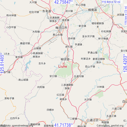
Liuhe GPS coordinates[2]
42° 14' 24.252" North, 125° 43' 1.812" East
| Map corner | latitude | longitude |
|---|---|---|
| Upper-left | 42.75847°, | 125.01405° |
| Center: | 42.24007°, | 125.71717° |
| Lower-right: | 41.71738°, | 126.4203° |
| Map W x H: | 115.8×115.8 km | = 72×72mi |
| max Lat: | 53.31946° ⇑8.8% North |
| Liuhe: | 42.24007° |
| min Lat: | ⇓91.2% South 18.22056° |
| min Long | Liuhe | max Long |
| 75.07348° | 125.71717° | 134.28917° |
| W 95.2%⇐ | ⇒4.8% E |
Elevation
Elevation of Liuhe is 399 m = 1309 ft, and this is 85.8 m = 281 ft below average elevation for this country.
| Max E: |
5622 m = 18445 ft | 30.6% |
| Avg. | 484.8 m = 1591 ft | |
| Liuhe | 399 m = 1309 ft | |
Min E: |
-3 m = -10 ft | 69.4% |
See also: Liuhe elevation on elevation.city.
Geographical zone
Liuhe is located in North temperate zone (between Tropic of Cancer and the Arctic Circle). Distance of this Northern Tropic circle is 2090.7 km =1299.1 mi to South.| Distance of | km | miles | from Liuhe |
|---|---|---|---|
| North Pole | 5310.4 | 3299.7 | to North |
| Arctic Circle | 2704.5 | 1680.5 | to North |
| Tropic Cancer | 2090.7 | 1299.1 | to South |
| Equator | 4696.7 | 2918.4 | to South |


Nearby cities:
15 places around Liuhe: (largest is in red/bold)
• Chaoyang
53.4 km =33.2 mi,  28°
28°
• Dahuanggou
39.8 km =24.7 mi,  121°
121°
• Da’an
56.3 km =35 mi,  143°
143°
• Dongfeng
47.6 km =29.6 mi,  339°
339°
• Erdaojiang
57.7 km =35.9 mi,  153°
153°
• Ermi
51.1 km =31.8 mi,  169°
169°
• Gangou
41.9 km =26 mi,  180°
180°
• Guanghua
39.5 km =24.5 mi, 145°
• Hulutao
53 km =32.9 mi,  159°
159°
• Jindou
59.6 km =37 mi, 182°
• Meihekou
32.1 km =19.9 mi,  353°
353°
• Sipeng
43.7 km =27.2 mi,  195°
195°
• Tonghua
60.4 km =37.5 mi, 163°
• Tongshanjie
45.8 km =28.5 mi, 166°
• Ying’ebu
58.2 km =36.2 mi,  193°
193°
Sources, notices
• [Note1] Compared only with cities in China existing in our database
• [Src1] Map data: © OpenStreetMap contributors (CC-BY-SA)
• [Src2] Other city data from geonames.org with taken over terms of usage.
• [Src3] Geographical zone / Annual Mean Temperature by Robert A. Rohde @ Wikipedia
