Dongfeng geodata
Dongfeng (Jilin) is a seat of a third-order administrative division; located in China in Asia/Shanghai (GMT+8) time zone. With population of 67,820 people, there are 632 cities with bigger population in this country. Compared to other cities in China, 91.5% of cities are located further ↓South; 95% of cities are located further ←West and 66.4% of cities have lower elevation than Dongfeng. Note1


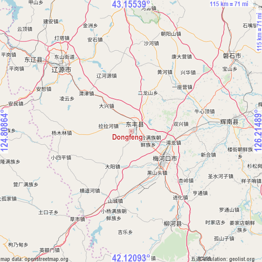
Dongfeng GPS coordinates[2]
42° 38' 25.116" North, 125° 30' 42.336" East
| Map corner | latitude | longitude |
|---|---|---|
| Upper-left | 43.15539°, | 124.80864° |
| Center: | 42.64031°, | 125.51176° |
| Lower-right: | 42.12093°, | 126.21489° |
| Map W x H: | 115×115 km | = 71.5×71.5mi |
| max Lat: | 53.31946° ⇑8.5% North |
| Dongfeng: | 42.64031° |
| min Lat: | ⇓91.5% South 18.22056° |
| min Long | Dongfeng | max Long |
| 75.07348° | 125.51176° | 134.28917° |
| W 95%⇐ | ⇒5% E |
Elevation
Elevation of Dongfeng is 350 m = 1148 ft, and this is 134.8 m = 442 ft below average elevation for this country.
| Max E: |
5622 m = 18445 ft | 33.6% |
| Avg. | 484.8 m = 1591 ft | |
| Dongfeng | 350 m = 1148 ft | |
Min E: |
-3 m = -10 ft | 66.4% |
See also: Dongfeng elevation on elevation.city.
Geographical zone
Dongfeng is located in North temperate zone (between Tropic of Cancer and the Arctic Circle). Distance of this Northern Tropic circle is 2135.2 km =1326.8 mi to South.| Distance of | km | miles | from Dongfeng |
|---|---|---|---|
| North Pole | 5265.9 | 3272.1 | to North |
| Arctic Circle | 2660 | 1652.8 | to North |
| Tropic Cancer | 2135.2 | 1326.8 | to South |
| Equator | 4741.2 | 2946 | to South |


Nearby cities:
15 places around Dongfeng: (largest is in red/bold)
• Baiquan
52.8 km =32.8 mi,  301°
301°
• Chaoyang
42.1 km =26.2 mi,  86°
86°
• Dahuanggou
82.8 km =51.4 mi,  142°
142°
• Dasuhe
92.4 km =57.4 mi,  209°
209°
• Gangou
88 km =54.7 mi,  169°
169°
• Guanghua
86.5 km =53.7 mi,  153°
153°
• Huinan
61.4 km =38.2 mi, 91°
• Liaoyuan
42.4 km =26.3 mi,  313°
313°
• Liuhe
47.6 km =29.6 mi,  159°
159°
• Meihekou
18.4 km =11.4 mi,  133°
133°
• Panshi
55.7 km =34.6 mi,  52°
52°
• Sipeng
86.7 km =53.9 mi,  176°
176°
• Xifeng
65.4 km =40.6 mi,  279°
279°
• Yantongshan
83 km =51.6 mi,  29°
29°
• Yitong
78.2 km =48.6 mi,  347°
347°
Sources, notices
• [Note1] Compared only with cities in China existing in our database
• [Src1] Map data: © OpenStreetMap contributors (CC-BY-SA)
• [Src2] Other city data from geonames.org with taken over terms of usage.
• [Src3] Geographical zone / Annual Mean Temperature by Robert A. Rohde @ Wikipedia
