Lianhua geodata
Lianhua (Heilongjiang) is a seat of a fourth-order administrative division; located in China in Asia/Shanghai (GMT+8) time zone. In our database, there are 1268 cities with bigger population. Compared to other cities in China, 96.9% of cities are located further ↓South; 96.4% of cities are located further ←West and 57.4% of cities have lower elevation than Lianhua. Note1


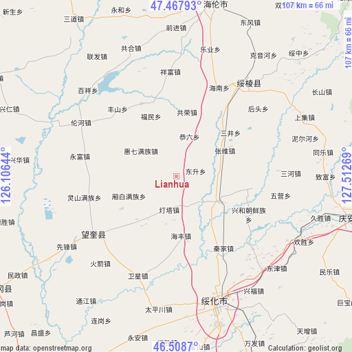
Lianhua GPS coordinates[2]
46° 59' 25.692" North, 126° 48' 34.416" East
| Map corner | latitude | longitude |
|---|---|---|
| Upper-left | 47.46793°, | 126.10644° |
| Center: | 46.99047°, | 126.80956° |
| Lower-right: | 46.5087°, | 127.51269° |
| Map W x H: | 106.7×106.7 km | = 66.3×66.3mi |
| max Lat: | 53.31946° ⇑3.1% North |
| Lianhua: | 46.99047° |
| min Lat: | ⇓96.9% South 18.22056° |
| min Long | Lianhua | max Long |
| 75.07348° | 126.80956° | 134.28917° |
| W 96.4%⇐ | ⇒3.6% E |
Elevation
Elevation of Lianhua is 229 m = 751 ft, and this is 255.8 m = 839 ft below average elevation for this country.
| Max E: |
5622 m = 18445 ft | 42.6% |
| Avg. | 484.8 m = 1591 ft | |
| Lianhua | 229 m = 751 ft | |
Min E: |
-3 m = -10 ft | 57.4% |
See also: China elevation on elevation.city.
Geographical zone
Lianhua is located in North temperate zone (between Tropic of Cancer and the Arctic Circle). Distance of this North polar circle is 2176.3 km =1352.3 mi to North.| Distance of | km | miles | from Lianhua |
|---|---|---|---|
| North Pole | 4782.2 | 2971.5 | to North |
| Arctic Circle | 2176.3 | 1352.3 | to North |
| Tropic Cancer | 2618.9 | 1627.3 | to South |
| Equator | 5224.9 | 3246.6 | to South |


Nearby cities:
15 places around Lianhua: (largest is in red/bold)
• Dengta
10.3 km =6.4 mi,  192°
192°
• Dongsheng
5.9 km =3.7 mi,  75°
75°
• Fengshan
26.8 km =16.7 mi,  318°
318°
• Fumin
19.6 km =12.2 mi,  337°
337°
• Gongliu
12.8 km =8 mi,  18°
18°
• Gongrong
19.7 km =12.2 mi,  9°
9°
• Haifeng
18.1 km =11.2 mi,  175°
175°
• Haixing
24.4 km =15.2 mi,  334°
334°
• Huiqi
13.1 km =8.1 mi,  305°
305°
• Qinjia
26 km =16.2 mi,  146°
146°
• Sanjing
21 km =13 mi,  51°
51°
• Sifangtai
15.2 km =9.4 mi,  120°
120°
• Xiangbai
15.4 km =9.6 mi,  247°
247°
• Xinghe
25 km =15.5 mi, 117°
• Zhangxiong
16.5 km =10.3 mi,  62°
62°
Sources, notices
• [Note1] Compared only with cities in China existing in our database
• [Src1] Map data: © OpenStreetMap contributors (CC-BY-SA)
• [Src2] Other city data from geonames.org with taken over terms of usage.
• [Src3] Geographical zone / Annual Mean Temperature by Robert A. Rohde @ Wikipedia
