Dongsheng geodata
Dongsheng (Heilongjiang) is a seat of a fourth-order administrative division; located in China in Asia/Shanghai (GMT+8) time zone. In our database, there are 1268 cities with bigger population. Compared to other cities in China, 97% of cities are located further ↓South; 96.5% of cities are located further ←West and 57.9% of cities have lower elevation than Dongsheng. Note1


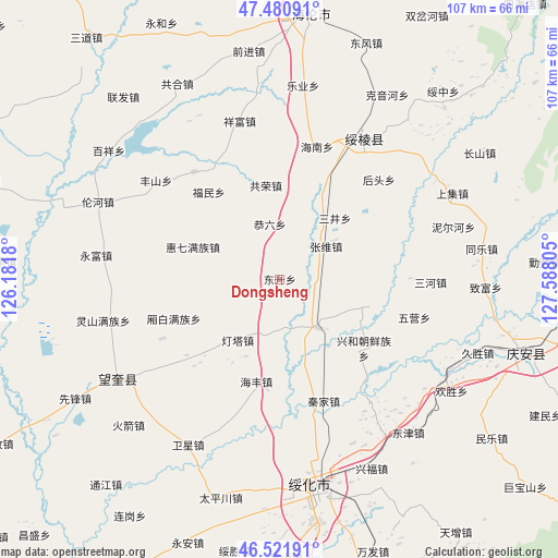
Dongsheng GPS coordinates[2]
47° 0' 12.816" North, 126° 53' 5.712" East
| Map corner | latitude | longitude |
|---|---|---|
| Upper-left | 47.48091°, | 126.1818° |
| Center: | 47.00356°, | 126.88492° |
| Lower-right: | 46.52191°, | 127.58805° |
| Map W x H: | 106.6×106.6 km | = 66.2×66.2mi |
| max Lat: | 53.31946° ⇑3% North |
| Dongsheng: | 47.00356° |
| min Lat: | ⇓97% South 18.22056° |
| min Long | Dongsheng | max Long |
| 75.07348° | 126.88492° | 134.28917° |
| W 96.5%⇐ | ⇒3.5% E |
Elevation
Elevation of Dongsheng is 235 m = 771 ft, and this is 249.8 m = 820 ft below average elevation for this country.
| Max E: |
5622 m = 18445 ft | 42.1% |
| Avg. | 484.8 m = 1591 ft | |
| Dongsheng | 235 m = 771 ft | |
Min E: |
-3 m = -10 ft | 57.9% |
See also: China elevation on elevation.city.
Geographical zone
Dongsheng is located in North temperate zone (between Tropic of Cancer and the Arctic Circle). Distance of this North polar circle is 2174.9 km =1351.4 mi to North.| Distance of | km | miles | from Dongsheng |
|---|---|---|---|
| North Pole | 4780.8 | 2970.7 | to North |
| Arctic Circle | 2174.9 | 1351.4 | to North |
| Tropic Cancer | 2620.4 | 1628.2 | to South |
| Equator | 5226.3 | 3247.5 | to South |


Nearby cities:
15 places around Dongsheng: (largest is in red/bold)
• Dengta
13.9 km =8.6 mi,  214°
214°
• Fumin
21.2 km =13.2 mi,  322°
322°
• Gongliu
10.8 km =6.7 mi,  350°
350°
• Gongrong
18.1 km =11.2 mi, 352°
• Haifeng
20 km =12.4 mi,  192°
192°
• Haixing
26.2 km =16.3 mi, 321°
• Huiqi
17.5 km =10.9 mi,  290°
290°
• Lianhua
5.9 km =3.7 mi,  255°
255°
• Qinjia
24.7 km =15.3 mi,  159°
159°
• Sanjing
15.8 km =9.8 mi,  42°
42°
• Shuanghe
25.3 km =15.7 mi,  122°
122°
• Sifangtai
11.8 km =7.3 mi,  141°
141°
• Xiangbai
21.2 km =13.2 mi,  249°
249°
• Xinghe
21 km =13 mi,  128°
128°
• Zhangxiong
10.9 km =6.8 mi,  54°
54°
Sources, notices
• [Note1] Compared only with cities in China existing in our database
• [Src1] Map data: © OpenStreetMap contributors (CC-BY-SA)
• [Src2] Other city data from geonames.org with taken over terms of usage.
• [Src3] Geographical zone / Annual Mean Temperature by Robert A. Rohde @ Wikipedia
