Fumin geodata
Fumin (Heilongjiang) is a seat of a fourth-order administrative division; located in China in Asia/Shanghai (GMT+8) time zone. In our database, there are 1268 cities with bigger population. Compared to other cities in China, 97.2% of cities are located further ↓South; 96.3% of cities are located further ←West and 56.8% of cities have lower elevation than Fumin. Note1


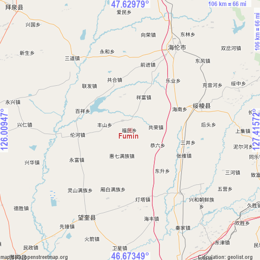
Fumin GPS coordinates[2]
47° 9' 13.644" North, 126° 42' 45.324" East
| Map corner | latitude | longitude |
|---|---|---|
| Upper-left | 47.62979°, | 126.00947° |
| Center: | 47.15379°, | 126.71259° |
| Lower-right: | 46.67349°, | 127.41572° |
| Map W x H: | 106.3×106.3 km | = 66.1×66.1mi |
| max Lat: | 53.31946° ⇑2.8% North |
| Fumin: | 47.15379° |
| min Lat: | ⇓97.2% South 18.22056° |
| min Long | Fumin | max Long |
| 75.07348° | 126.71259° | 134.28917° |
| W 96.3%⇐ | ⇒3.7% E |
Elevation
Elevation of Fumin is 224 m = 735 ft, and this is 260.8 m = 856 ft below average elevation for this country.
| Max E: |
5622 m = 18445 ft | 43.2% |
| Avg. | 484.8 m = 1591 ft | |
| Fumin | 224 m = 735 ft | |
Min E: |
-3 m = -10 ft | 56.8% |
See also: China elevation on elevation.city.
Geographical zone
Fumin is located in North temperate zone (between Tropic of Cancer and the Arctic Circle). Distance of this North polar circle is 2158.2 km =1341 mi to North.| Distance of | km | miles | from Fumin |
|---|---|---|---|
| North Pole | 4764.1 | 2960.3 | to North |
| Arctic Circle | 2158.2 | 1341 | to North |
| Tropic Cancer | 2637.1 | 1638.6 | to South |
| Equator | 5243 | 3257.8 | to South |


Nearby cities:
15 places around Fumin: (largest is in red/bold)
• Baixiang
21.1 km =13.1 mi,  291°
291°
• Dongsheng
21.2 km =13.2 mi,  142°
142°
• Fengshan
10.5 km =6.5 mi,  281°
281°
• Gonghe
21.8 km =13.5 mi,  342°
342°
• Gongliu
12.8 km =8 mi,  117°
117°
• Gongrong
10.6 km =6.6 mi,  83°
83°
• Hainan
22.1 km =13.7 mi,  66°
66°
• Haixing
5 km =3.1 mi,  320°
320°
• Huiqi
11 km =6.8 mi,  197°
197°
• Leye
23.5 km =14.6 mi,  48°
48°
• Lianhua
19.6 km =12.2 mi,  157°
157°
• Lunhe
21.5 km =13.4 mi,  265°
265°
• Sanjing
24.2 km =15 mi,  101°
101°
• Xiangfu
14.5 km =9 mi,  21°
21°
• Zhangxiong
24.3 km =15.1 mi, 115°
Sources, notices
• [Note1] Compared only with cities in China existing in our database
• [Src1] Map data: © OpenStreetMap contributors (CC-BY-SA)
• [Src2] Other city data from geonames.org with taken over terms of usage.
• [Src3] Geographical zone / Annual Mean Temperature by Robert A. Rohde @ Wikipedia
