Gongliu geodata
Gongliu (Heilongjiang) is a seat of a fourth-order administrative division; located in China in Asia/Shanghai (GMT+8) time zone. In our database, there are 1268 cities with bigger population. Compared to other cities in China, 97.1% of cities are located further ↓South; 96.4% of cities are located further ←West and 55.4% of cities have lower elevation than Gongliu. Note1


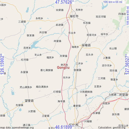
Gongliu GPS coordinates[2]
47° 5' 59.208" North, 126° 51' 43.704" East
| Map corner | latitude | longitude |
|---|---|---|
| Upper-left | 47.57626°, | 126.15902° |
| Center: | 47.09978°, | 126.86214° |
| Lower-right: | 46.61899°, | 127.56527° |
| Map W x H: | 106.4×106.4 km | = 66.1×66.1mi |
| max Lat: | 53.31946° ⇑2.9% North |
| Gongliu: | 47.09978° |
| min Lat: | ⇓97.1% South 18.22056° |
| min Long | Gongliu | max Long |
| 75.07348° | 126.86214° | 134.28917° |
| W 96.4%⇐ | ⇒3.6% E |
Elevation
Elevation of Gongliu is 210 m = 689 ft, and this is 274.8 m = 902 ft below average elevation for this country.
| Max E: |
5622 m = 18445 ft | 44.6% |
| Avg. | 484.8 m = 1591 ft | |
| Gongliu | 210 m = 689 ft | |
Min E: |
-3 m = -10 ft | 55.4% |
See also: China elevation on elevation.city.
Geographical zone
Gongliu is located in North temperate zone (between Tropic of Cancer and the Arctic Circle). Distance of this North polar circle is 2164.2 km =1344.8 mi to North.| Distance of | km | miles | from Gongliu |
|---|---|---|---|
| North Pole | 4770.1 | 2964 | to North |
| Arctic Circle | 2164.2 | 1344.8 | to North |
| Tropic Cancer | 2631.1 | 1634.9 | to South |
| Equator | 5237 | 3254.1 | to South |


Nearby cities:
15 places around Gongliu: (largest is in red/bold)
• Dengta
23 km =14.3 mi,  195°
195°
• Dongsheng
10.8 km =6.7 mi,  170°
170°
• Fengshan
23.1 km =14.4 mi,  290°
290°
• Fumin
12.8 km =8 mi,  297°
297°
• Gongrong
7.3 km =4.5 mi,  353°
353°
• Hainan
17.2 km =10.7 mi,  31°
31°
• Haixing
17.6 km =10.9 mi, 304°
• Houtou
22.5 km =14 mi,  68°
68°
• Huiqi
15.2 km =9.4 mi,  252°
252°
• Leye
22.3 km =13.9 mi,  16°
16°
• Lianhua
12.8 km =8 mi, 198°
• Sanjing
12.4 km =7.7 mi,  85°
85°
• Sifangtai
21.9 km =13.6 mi,  155°
155°
• Xiangfu
20.5 km =12.7 mi,  342°
342°
• Zhangxiong
11.5 km =7.1 mi,  112°
112°
Sources, notices
• [Note1] Compared only with cities in China existing in our database
• [Src1] Map data: © OpenStreetMap contributors (CC-BY-SA)
• [Src2] Other city data from geonames.org with taken over terms of usage.
• [Src3] Geographical zone / Annual Mean Temperature by Robert A. Rohde @ Wikipedia
