Lianghe geodata
Lianghe (Heilongjiang) is a seat of a fourth-order administrative division; located in China in Asia/Shanghai (GMT+8) time zone. In our database, there are 1268 cities with bigger population. Compared to other cities in China, 94% of cities are located further ↓South; 98.3% of cities are located further ←West and 56.1% of cities have lower elevation than Lianghe. Note1


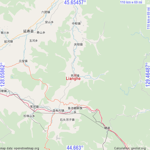
Lianghe GPS coordinates[2]
45° 9' 39.384" North, 128° 45' 42.264" East
| Map corner | latitude | longitude |
|---|---|---|
| Upper-left | 45.65457°, | 128.05862° |
| Center: | 45.16094°, | 128.76174° |
| Lower-right: | 44.663°, | 129.46487° |
| Map W x H: | 110.3×110.3 km | = 68.5×68.5mi |
| max Lat: | 53.31946° ⇑6% North |
| Lianghe: | 45.16094° |
| min Lat: | ⇓94% South 18.22056° |
| min Long | Lianghe | max Long |
| 75.07348° | 128.76174° | 134.28917° |
| W 98.3%⇐ | ⇒1.7% E |
Elevation
Elevation of Lianghe is 217 m = 712 ft, and this is 267.8 m = 879 ft below average elevation for this country.
| Max E: |
5622 m = 18445 ft | 43.9% |
| Avg. | 484.8 m = 1591 ft | |
| Lianghe | 217 m = 712 ft | |
Min E: |
-3 m = -10 ft | 56.1% |
See also: China elevation on elevation.city.
Geographical zone
Lianghe is located in North temperate zone (between Tropic of Cancer and the Arctic Circle). Distance of this North polar circle is 2379.7 km =1478.7 mi to North.| Distance of | km | miles | from Lianghe |
|---|---|---|---|
| North Pole | 4985.6 | 3097.9 | to North |
| Arctic Circle | 2379.7 | 1478.7 | to North |
| Tropic Cancer | 2415.5 | 1500.9 | to South |
| Equator | 5021.4 | 3120.2 | to South |


Nearby cities:
15 places around Lianghe: (largest is in red/bold)
• Anshan
43.3 km =26.9 mi,  334°
334°
• Hengdaohezi
46.1 km =28.6 mi,  148°
148°
• Liutuan
51.1 km =31.8 mi,  335°
335°
• Qingyang
22.9 km =14.2 mi,  5°
5°
• Shitouhezi
32.9 km =20.4 mi,  190°
190°
• Shoushan
40.5 km =25.2 mi,  321°
321°
• Weihe
37.9 km =23.5 mi,  232°
232°
• Yabuli
28.4 km =17.6 mi,  205°
205°
• Yanhe
55 km =34.2 mi,  297°
297°
• Yanshou
47 km =29.2 mi,  313°
313°
• Yuanbao
39.7 km =24.7 mi,  285°
285°
• Yuchi
25.5 km =15.8 mi,  179°
179°
• Yuhe
40.1 km =24.9 mi, 310°
• Zhenzhushan
45.1 km =28 mi, 228°
• Zhonghe
38.3 km =23.8 mi,  1°
1°
Sources, notices
• [Note1] Compared only with cities in China existing in our database
• [Src1] Map data: © OpenStreetMap contributors (CC-BY-SA)
• [Src2] Other city data from geonames.org with taken over terms of usage.
• [Src3] Geographical zone / Annual Mean Temperature by Robert A. Rohde @ Wikipedia
