Shitouhezi geodata
Shitouhezi (Heilongjiang) is a seat of a fourth-order administrative division; located in China in Asia/Shanghai (GMT+8) time zone. In our database, there are 1268 cities with bigger population. Compared to other cities in China, 93.7% of cities are located further ↓South; 98.2% of cities are located further ←West and 65.5% of cities have lower elevation than Shitouhezi. Note1


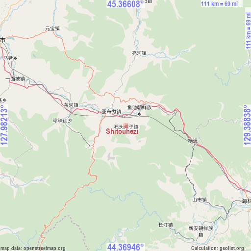
Shitouhezi GPS coordinates[2]
44° 52' 11.748" North, 128° 41' 6.9" East
| Map corner | latitude | longitude |
|---|---|---|
| Upper-left | 45.36608°, | 127.98213° |
| Center: | 44.86993°, | 128.68525° |
| Lower-right: | 44.36946°, | 129.38838° |
| Map W x H: | 110.8×110.8 km | = 68.8×68.8mi |
| max Lat: | 53.31946° ⇑6.3% North |
| Shitouhezi: | 44.86993° |
| min Lat: | ⇓93.7% South 18.22056° |
| min Long | Shitouhezi | max Long |
| 75.07348° | 128.68525° | 134.28917° |
| W 98.2%⇐ | ⇒1.8% E |
Elevation
Elevation of Shitouhezi is 334 m = 1096 ft, and this is 150.8 m = 495 ft below average elevation for this country.
| Max E: |
5622 m = 18445 ft | 34.5% |
| Avg. | 484.8 m = 1591 ft | |
| Shitouhezi | 334 m = 1096 ft | |
Min E: |
-3 m = -10 ft | 65.5% |
See also: China elevation on elevation.city.
Geographical zone
Shitouhezi is located in North temperate zone (between Tropic of Cancer and the Arctic Circle). Distance of this Northern Tropic circle is 2383.1 km =1480.8 mi to South.| Distance of | km | miles | from Shitouhezi |
|---|---|---|---|
| North Pole | 5018 | 3118 | to North |
| Arctic Circle | 2412.1 | 1498.8 | to North |
| Tropic Cancer | 2383.1 | 1480.8 | to South |
| Equator | 4989.1 | 3100.1 | to South |


Nearby cities:
15 places around Shitouhezi: (largest is in red/bold)
• Changting
48.2 km =30 mi,  157°
157°
• Hengdaohezi
31 km =19.3 mi,  102°
102°
• Jiujie
62.2 km =38.6 mi,  149°
149°
• Laojieji
58 km =36 mi,  281°
281°
• Lianghe
32.9 km =20.4 mi,  10°
10°
• Qingyang
55.8 km =34.7 mi, 8°
• Shanshi
46 km =28.6 mi,  135°
135°
• Shihe
60.3 km =37.5 mi,  131°
131°
• Weihe
26 km =16.2 mi,  291°
291°
• Xin’an
60.6 km =37.7 mi, 145°
• Yabuli
9 km =5.6 mi,  317°
317°
• Yuanbao
53.9 km =33.5 mi, 323°
• Yuchi
9.1 km =5.7 mi,  41°
41°
• Yuhe
63.2 km =39.3 mi,  336°
336°
• Zhenzhushan
28 km =17.4 mi, 275°
Sources, notices
• [Note1] Compared only with cities in China existing in our database
• [Src1] Map data: © OpenStreetMap contributors (CC-BY-SA)
• [Src2] Other city data from geonames.org with taken over terms of usage.
• [Src3] Geographical zone / Annual Mean Temperature by Robert A. Rohde @ Wikipedia
