Guanyinge geodata
Guanyinge (Liaoning) is a seat of a fourth-order administrative division; located in China in Asia/Shanghai (GMT+8) time zone. In our database, there are 1268 cities with bigger population. Compared to other cities in China, 89.8% of cities are located further ↓South; 93.9% of cities are located further ←West and 54.3% of cities have lower elevation than Guanyinge. Note1


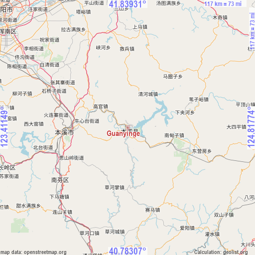
Guanyinge GPS coordinates[2]
41° 18' 47.988" North, 124° 6' 52.596" East
| Map corner | latitude | longitude |
|---|---|---|
| Upper-left | 41.83931°, | 123.41149° |
| Center: | 41.31333°, | 124.11461° |
| Lower-right: | 40.78307°, | 124.81774° |
| Map W x H: | 117.4×117.4 km | = 72.9×72.9mi |
| max Lat: | 53.31946° ⇑10.2% North |
| Guanyinge: | 41.31333° |
| min Lat: | ⇓89.8% South 18.22056° |
| min Long | Guanyinge | max Long |
| 75.07348° | 124.11461° | 134.28917° |
| W 93.9%⇐ | ⇒6.1% E |
Elevation
Elevation of Guanyinge is 200 m = 656 ft, and this is 284.8 m = 934 ft below average elevation for this country.
| Max E: |
5622 m = 18445 ft | 45.7% |
| Avg. | 484.8 m = 1591 ft | |
| Guanyinge | 200 m = 656 ft | |
Min E: |
-3 m = -10 ft | 54.3% |
See also: China elevation on elevation.city.
Geographical zone
Guanyinge is located in North temperate zone (between Tropic of Cancer and the Arctic Circle). Distance of this Northern Tropic circle is 1987.7 km =1235.1 mi to South.| Distance of | km | miles | from Guanyinge |
|---|---|---|---|
| North Pole | 5413.5 | 3363.8 | to North |
| Arctic Circle | 2807.6 | 1744.6 | to North |
| Tropic Cancer | 1987.7 | 1235.1 | to South |
| Equator | 4593.6 | 2854.3 | to South |


Nearby cities:
15 places around Guanyinge: (largest is in red/bold)
• Benxi
29.3 km =18.2 mi,  264°
264°
• Caohekou
51.4 km =31.9 mi,  200°
200°
• Caohezhang
28 km =17.4 mi,  192°
192°
• Dasiping
50 km =31.1 mi,  89°
89°
• Dongyingfang
35.7 km =22.2 mi,  106°
106°
• Hou’an
44.2 km =27.5 mi,  10°
10°
• Jianchang
30.6 km =19 mi,  103°
103°
• Jiubing
36.6 km =22.7 mi,  359°
359°
• Majuanzi
31.8 km =19.8 mi,  42°
42°
• Nandianzi
21.6 km =13.4 mi, 99°
• Qinghecheng
18.2 km =11.3 mi,  30°
30°
• Shangma
52.1 km =32.4 mi,  3°
3°
• Tianshifu
20.9 km =13 mi, 107°
• Weiziyu
35.3 km =21.9 mi,  67°
67°
• Xiaoshi
1.9 km =1.2 mi,  163°
163°
Sources, notices
• [Note1] Compared only with cities in China existing in our database
• [Src1] Map data: © OpenStreetMap contributors (CC-BY-SA)
• [Src2] Other city data from geonames.org with taken over terms of usage.
• [Src3] Geographical zone / Annual Mean Temperature by Robert A. Rohde @ Wikipedia
