Shenyang geodata
Shenyang (Liaoning) is a seat of a first-order administrative division; located in China in Asia/Shanghai (GMT+8) time zone. With population of 6,255,921 people, there are 12 cities with bigger population in this country. Compared to other cities in China, 90.7% of cities are located further ↓South; 93.2% of cities are located further ←West and 69.7% of cities have higher elevation than Shenyang. Note1


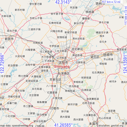
Shenyang GPS coordinates[2]
41° 47' 31.992" North, 123° 25' 58.008" East
| Map corner | latitude | longitude |
|---|---|---|
| Upper-left | 42.3143°, | 122.72966° |
| Center: | 41.79222°, | 123.43278° |
| Lower-right: | 41.26585°, | 124.13591° |
| Map W x H: | 116.6×116.6 km | = 72.5×72.5mi |
| max Lat: | 53.31946° ⇑9.3% North |
| Shenyang: | 41.79222° |
| min Lat: | ⇓90.7% South 18.22056° |
| min Long | Shenyang | max Long |
| 75.07348° | 123.43278° | 134.28917° |
| W 93.2%⇐ | ⇒6.8% E |
Elevation
Elevation of Shenyang is 53 m = 174 ft, and this is 431.8 m = 1417 ft below average elevation for this country.
| Max E: |
5622 m = 18445 ft | 69.7% |
| Avg. | 484.8 m = 1591 ft | |
| Shenyang | 53 m = 174 ft | |
Min E: |
-3 m = -10 ft | 30.3% |
See also: Shenyang elevation on elevation.city.
Geographical zone
Shenyang is located in North temperate zone (between Tropic of Cancer and the Arctic Circle). Distance of this Northern Tropic circle is 2040.9 km =1268.2 mi to South.| Distance of | km | miles | from Shenyang |
|---|---|---|---|
| North Pole | 5360.2 | 3330.7 | to North |
| Arctic Circle | 2754.3 | 1711.4 | to North |
| Tropic Cancer | 2040.9 | 1268.2 | to South |
| Equator | 4646.9 | 2887.4 | to South |


Nearby cities:
15 places around Shenyang: (largest is in red/bold)
• Dongling
12.1 km =7.5 mi,  78°
78°
• Dongzhou
50.8 km =31.6 mi, 80°
• Fushun
43.6 km =27.1 mi, 76°
• Hada
62 km =38.5 mi,  71°
71°
• Hushitai
17.6 km =10.9 mi,  19°
19°
• Jiubing
58.6 km =36.4 mi,  106°
106°
• Lanshan
54.9 km =34.1 mi,  89°
89°
• Liaoyang
61.8 km =38.4 mi,  200°
200°
• Nianpan
50.2 km =31.2 mi, 86°
• Qiandian
48.5 km =30.1 mi, 76°
• Shangma
59.5 km =37 mi, 91°
• Sujiatun
16.7 km =10.4 mi,  207°
207°
• Xinmin
54.9 km =34.1 mi,  293°
293°
• Zhangdang
54.7 km =34 mi, 76°
• Zhangdian
50.5 km =31.4 mi, 86°
Sources, notices
• [Note1] Compared only with cities in China existing in our database
• [Src1] Map data: © OpenStreetMap contributors (CC-BY-SA)
• [Src2] Other city data from geonames.org with taken over terms of usage.
• [Src3] Geographical zone / Annual Mean Temperature by Robert A. Rohde @ Wikipedia
