Baoshan geodata
Baoshan (Heilongjiang) is a populated place; located in China in Asia/Shanghai (GMT+8) time zone. With population of 123,791 people, there are 357 cities with bigger population in this country. Compared to other cities in China, 96% of cities are located further ↓South; 100% of cities are located further ←West and 50.2% of cities have lower elevation than Baoshan. Note1


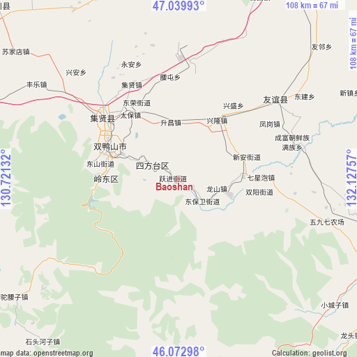
Baoshan GPS coordinates[2]
46° 33' 30.996" North, 131° 25' 27.984" East
| Map corner | latitude | longitude |
|---|---|---|
| Upper-left | 47.03993°, | 130.72132° |
| Center: | 46.55861°, | 131.42444° |
| Lower-right: | 46.07298°, | 132.12757° |
| Map W x H: | 107.5×107.5 km | = 66.8×66.8mi |
| max Lat: | 53.31946° ⇑4% North |
| Baoshan: | 46.55861° |
| min Lat: | ⇓96% South 18.22056° |
| min Long | Baoshan | max Long |
| 75.07348° | 131.42444° | 134.28917° |
| W 100%⇐ | ⇒0% E |
Elevation
Elevation of Baoshan is 167 m = 548 ft, and this is 317.8 m = 1043 ft below average elevation for this country.
| Max E: |
5622 m = 18445 ft | 49.8% |
| Avg. | 484.8 m = 1591 ft | |
| Baoshan | 167 m = 548 ft | |
Min E: |
-3 m = -10 ft | 50.2% |
See also: Baoshan elevation on elevation.city.
Geographical zone
Baoshan is located in North temperate zone (between Tropic of Cancer and the Arctic Circle). Distance of this North polar circle is 2224.3 km =1382.1 mi to North.| Distance of | km | miles | from Baoshan |
|---|---|---|---|
| North Pole | 4830.2 | 3001.3 | to North |
| Arctic Circle | 2224.3 | 1382.1 | to North |
| Tropic Cancer | 2570.9 | 1597.5 | to South |
| Equator | 5176.8 | 3216.7 | to South |


Nearby cities:
15 places around Baoshan: (largest is in red/bold)
• Baoqing
65.3 km =40.6 mi,  112°
112°
• Chuangye
71.4 km =44.4 mi,  303°
303°
• Fengle
51.4 km =31.9 mi, 303°
• Fuli
28.3 km =17.6 mi,  309°
309°
• Hengtoushan
65.4 km =40.6 mi,  280°
280°
• Lingdong
21.4 km =13.3 mi,  272°
272°
• Mengjiagang
60.4 km =37.5 mi,  255°
255°
• Shitouhe
64.1 km =39.8 mi,  219°
219°
• Shuangyashan
22.4 km =13.9 mi,  292°
292°
• Simajia
65.9 km =40.9 mi, 290°
• Sujiadian
62.2 km =38.6 mi, 307°
• Taiping
59.8 km =37.2 mi, 292°
• Tuoyaozi
61.1 km =38 mi,  234°
234°
• Xinghuo
73.8 km =45.9 mi, 302°
• Yuelai
74.9 km =46.5 mi, 313°
Sources, notices
• [Note1] Compared only with cities in China existing in our database
• [Src1] Map data: © OpenStreetMap contributors (CC-BY-SA)
• [Src2] Other city data from geonames.org with taken over terms of usage.
• [Src3] Geographical zone / Annual Mean Temperature by Robert A. Rohde @ Wikipedia
