Fuli geodata
Fuli (Heilongjiang) is a populated place; located in China in Asia/Shanghai (GMT+8) time zone. With population of 59,160 people, there are 744 cities with bigger population in this country. Compared to other cities in China, 96.3% of cities are located further ↓South; 99.9% of cities are located further ←West and 59% of cities have higher elevation than Fuli. Note1


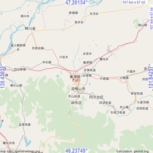
Fuli GPS coordinates[2]
46° 43' 18.012" North, 131° 8' 21.984" East
| Map corner | latitude | longitude |
|---|---|---|
| Upper-left | 47.20154°, | 130.43632° |
| Center: | 46.72167°, | 131.13944° |
| Lower-right: | 46.23749°, | 131.84257° |
| Map W x H: | 107.2×107.2 km | = 66.6×66.6mi |
| max Lat: | 53.31946° ⇑3.7% North |
| Fuli: | 46.72167° |
| min Lat: | ⇓96.3% South 18.22056° |
| min Long | Fuli | max Long |
| 75.07348° | 131.13944° | 134.28917° |
| W 99.9%⇐ | ⇒0.099999999999994% E |
Elevation
Elevation of Fuli is 104 m = 341 ft, and this is 380.8 m = 1249 ft below average elevation for this country.
| Max E: |
5622 m = 18445 ft | 59% |
| Avg. | 484.8 m = 1591 ft | |
| Fuli | 104 m = 341 ft | |
Min E: |
-3 m = -10 ft | 41% |
See also: Fuli elevation on elevation.city.
Geographical zone
Fuli is located in North temperate zone (between Tropic of Cancer and the Arctic Circle). Distance of this North polar circle is 2206.2 km =1370.9 mi to North.| Distance of | km | miles | from Fuli |
|---|---|---|---|
| North Pole | 4812.1 | 2990.1 | to North |
| Arctic Circle | 2206.2 | 1370.9 | to North |
| Tropic Cancer | 2589 | 1608.7 | to South |
| Equator | 5195 | 3228 | to South |


Nearby cities:
15 places around Fuli: (largest is in red/bold)
• Baoshan
28.3 km =17.6 mi,  129°
129°
• Changfa
51.2 km =31.8 mi,  271°
271°
• Chuangye
43.3 km =26.9 mi,  299°
299°
• Fengle
23.4 km =14.5 mi, 296°
• Hengtoushan
42.8 km =26.6 mi,  262°
262°
• Jianguo
48.1 km =29.9 mi,  290°
290°
• Lingdong
17.2 km =10.7 mi,  178°
178°
• Mengjiagang
49.5 km =30.8 mi,  227°
227°
• Shuangyashan
9.6 km =6 mi,  173°
173°
• Simajia
40.2 km =25 mi,  277°
277°
• Songjiang
55.3 km =34.4 mi, 283°
• Sujiadian
33.9 km =21.1 mi,  306°
306°
• Taiping
33.9 km =21.1 mi, 277°
• Xinghuo
45.9 km =28.5 mi, 297°
• Yuelai
46.6 km =29 mi,  315°
315°
Sources, notices
• [Note1] Compared only with cities in China existing in our database
• [Src1] Map data: © OpenStreetMap contributors (CC-BY-SA)
• [Src2] Other city data from geonames.org with taken over terms of usage.
• [Src3] Geographical zone / Annual Mean Temperature by Robert A. Rohde @ Wikipedia
