Baoqing geodata
Baoqing (Heilongjiang) is a populated place; located in China in Asia/Shanghai (GMT+8) time zone. With population of 62,991 people, there are 686 cities with bigger population in this country. Compared to other cities in China, 95.6% of cities are located further ↓South; 100% of cities are located further ←West and 62.6% of cities have higher elevation than Baoqing. Note1


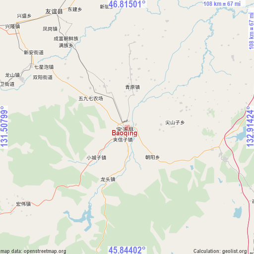
Baoqing GPS coordinates[2]
46° 19' 54.012" North, 132° 12' 39.996" East
| Map corner | latitude | longitude |
|---|---|---|
| Upper-left | 46.81501°, | 131.50799° |
| Center: | 46.33167°, | 132.21111° |
| Lower-right: | 45.84402°, | 132.91424° |
| Map W x H: | 108×108 km | = 67.1×67.1mi |
| max Lat: | 53.31946° ⇑4.4% North |
| Baoqing: | 46.33167° |
| min Lat: | ⇓95.6% South 18.22056° |
| min Long | Baoqing | max Long |
| 75.07348° | 132.21111° | 134.28917° |
| W 100%⇐ | ⇒0% E |
Elevation
Elevation of Baoqing is 84 m = 276 ft, and this is 400.8 m = 1315 ft below average elevation for this country.
| Max E: |
5622 m = 18445 ft | 62.6% |
| Avg. | 484.8 m = 1591 ft | |
| Baoqing | 84 m = 276 ft | |
Min E: |
-3 m = -10 ft | 37.4% |
See also: Baoqing elevation on elevation.city.
Geographical zone
Baoqing is located in North temperate zone (between Tropic of Cancer and the Arctic Circle). Distance of this North polar circle is 2249.6 km =1397.8 mi to North.| Distance of | km | miles | from Baoqing |
|---|---|---|---|
| North Pole | 4855.5 | 3017.1 | to North |
| Arctic Circle | 2249.6 | 1397.8 | to North |
| Tropic Cancer | 2545.7 | 1581.8 | to South |
| Equator | 5151.6 | 3201.1 | to South |


Nearby cities:
15 places around Baoqing: (largest is in red/bold)
• Baoshan
65.3 km =40.6 mi,  292°
292°
• Beishan
114.3 km =71 mi,  239°
239°
• Fengle
116.2 km =72.2 mi,  297°
297°
• Fujin
104.1 km =64.7 mi,  352°
352°
• Fuli
92.7 km =57.6 mi, 297°
• Hongqi
118.6 km =73.7 mi, 240°
• Lingdong
85.7 km =53.3 mi, 287°
• Mengjiagang
119.4 km =74.2 mi,  274°
274°
• Mishan
90.5 km =56.2 mi,  196°
196°
• Shitouhe
104.5 km =64.9 mi,  256°
256°
• Shuangyashan
87.7 km =54.5 mi, 292°
• Taihecun
122.5 km =76.1 mi, 238°
• Taiping
125.1 km =77.7 mi, 292°
• Tuoyaozi
110.6 km =68.7 mi, 264°
• Wanbaohe
114.1 km =70.9 mi, 237°
Sources, notices
• [Note1] Compared only with cities in China existing in our database
• [Src1] Map data: © OpenStreetMap contributors (CC-BY-SA)
• [Src2] Other city data from geonames.org with taken over terms of usage.
• [Src3] Geographical zone / Annual Mean Temperature by Robert A. Rohde @ Wikipedia
