Fujin geodata
Fujin (Heilongjiang) is a populated place; located in China in Asia/Shanghai (GMT+8) time zone. With population of 89,442 people, there are 477 cities with bigger population in this country. Compared to other cities in China, 97.5% of cities are located further ↓South; 100% of cities are located further ←West and 67.6% of cities have higher elevation than Fujin. Note1


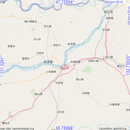
Fujin GPS coordinates[2]
47° 15' 36" North, 132° 1' 55.992" East
| Map corner | latitude | longitude |
|---|---|---|
| Upper-left | 47.73504°, | 131.3291° |
| Center: | 47.26°, | 132.03222° |
| Lower-right: | 46.78066°, | 132.73535° |
| Map W x H: | 106.1×106.1 km | = 65.9×65.9mi |
| max Lat: | 53.31946° ⇑2.5% North |
| Fujin: | 47.26° |
| min Lat: | ⇓97.5% South 18.22056° |
| min Long | Fujin | max Long |
| 75.07348° | 132.03222° | 134.28917° |
| W 100%⇐ | ⇒0% E |
Elevation
Elevation of Fujin is 62 m = 203 ft, and this is 422.8 m = 1387 ft below average elevation for this country.
| Max E: |
5622 m = 18445 ft | 67.6% |
| Avg. | 484.8 m = 1591 ft | |
| Fujin | 62 m = 203 ft | |
Min E: |
-3 m = -10 ft | 32.4% |
See also: Fujin elevation on elevation.city.
Geographical zone
Fujin is located in North temperate zone (between Tropic of Cancer and the Arctic Circle). Distance of this North polar circle is 2146.4 km =1333.7 mi to North.| Distance of | km | miles | from Fujin |
|---|---|---|---|
| North Pole | 4752.2 | 2952.9 | to North |
| Arctic Circle | 2146.4 | 1333.7 | to North |
| Tropic Cancer | 2648.9 | 1645.9 | to South |
| Equator | 5254.8 | 3265.2 | to South |


Nearby cities:
15 places around Fujin: (largest is in red/bold)
• Baoqing
104.1 km =64.7 mi,  172°
172°
• Baoshan
90.6 km =56.3 mi,  210°
210°
• Chuangye
111.7 km =69.4 mi,  249°
249°
• Dongming
96.2 km =59.8 mi,  291°
291°
• Fengle
101.5 km =63.1 mi,  240°
240°
• Fengxiang
97.5 km =60.6 mi, 291°
• Fuli
90.4 km =56.2 mi,  228°
228°
• Lingdong
102.4 km =63.6 mi,  221°
221°
• Mingshan
85.7 km =53.3 mi,  302°
302°
• Shuangyashan
96.2 km =59.8 mi, 223°
• Sujiadian
102.7 km =63.8 mi, 247°
• Tuanjie
90.9 km =56.5 mi, 285°
• Xinghuo
114.9 km =71.4 mi, 250°
• Yuelai
103.2 km =64.1 mi,  255°
255°
• Zhenxing
104.8 km =65.1 mi, 260°
Sources, notices
• [Note1] Compared only with cities in China existing in our database
• [Src1] Map data: © OpenStreetMap contributors (CC-BY-SA)
• [Src2] Other city data from geonames.org with taken over terms of usage.
• [Src3] Geographical zone / Annual Mean Temperature by Robert A. Rohde @ Wikipedia
