Bahui geodata
Bahui (Liaoning) is a seat of a fourth-order administrative division; located in China in Asia/Shanghai (GMT+8) time zone. In our database, there are 1268 cities with bigger population. Compared to other cities in China, 89% of cities are located further ↓South; 92.9% of cities are located further ←West and 50.2% of cities have higher elevation than Bahui. Note1


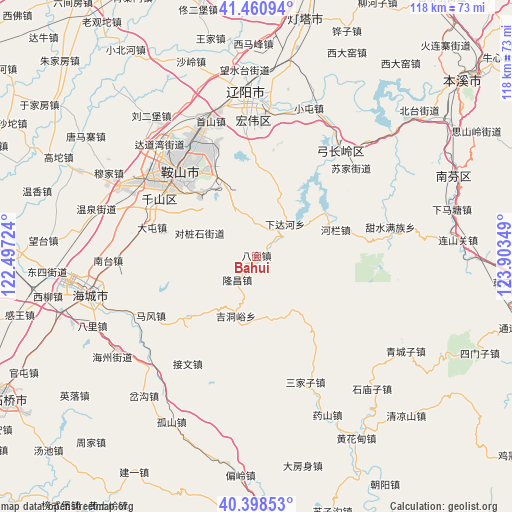
Bahui GPS coordinates[2]
40° 55' 54.732" North, 123° 12' 1.296" East
| Map corner | latitude | longitude |
|---|---|---|
| Upper-left | 41.46094°, | 122.49724° |
| Center: | 40.93187°, | 123.20036° |
| Lower-right: | 40.39853°, | 123.90349° |
| Map W x H: | 118.1×118.1 km | = 73.4×73.4mi |
| max Lat: | 53.31946° ⇑11% North |
| Bahui: | 40.93187° |
| min Lat: | ⇓89% South 18.22056° |
| min Long | Bahui | max Long |
| 75.07348° | 123.20036° | 134.28917° |
| W 92.9%⇐ | ⇒7.1% E |
Elevation
Elevation of Bahui is 163 m = 535 ft, and this is 321.8 m = 1056 ft below average elevation for this country.
| Max E: |
5622 m = 18445 ft | 50.2% |
| Avg. | 484.8 m = 1591 ft | |
| Bahui | 163 m = 535 ft | |
Min E: |
-3 m = -10 ft | 49.8% |
See also: China elevation on elevation.city.
Geographical zone
Bahui is located in North temperate zone (between Tropic of Cancer and the Arctic Circle). Distance of this Northern Tropic circle is 1945.3 km =1208.8 mi to South.| Distance of | km | miles | from Bahui |
|---|---|---|---|
| North Pole | 5455.9 | 3390.1 | to North |
| Arctic Circle | 2850 | 1770.9 | to North |
| Tropic Cancer | 1945.3 | 1208.8 | to South |
| Equator | 4551.2 | 2828 | to South |


Nearby cities:
15 places around Bahui: (largest is in red/bold)
• Anshan
27.7 km =17.2 mi,  320°
320°
• Datun
25.1 km =15.6 mi,  285°
285°
• Fu’an
34.9 km =21.7 mi,  297°
297°
• Ganquan
29.3 km =18.2 mi,  277°
277°
• Gongchangling
29.3 km =18.2 mi,  45°
45°
• Jiewen
29.6 km =18.4 mi,  213°
213°
• Jiupu
25.8 km =16 mi,  305°
305°
• Mafeng
28 km =17.4 mi,  240°
240°
• Muniu
30.5 km =19 mi,  176°
176°
• Nantai
33.3 km =20.7 mi,  268°
268°
• Sanjiazi
31.3 km =19.4 mi,  159°
159°
• Shangmatun
13.7 km =8.5 mi,  84°
84°
• Wangshi
33.3 km =20.7 mi,  256°
256°
• Xiadahe
9.7 km =6 mi,  40°
40°
• Ximu
35.7 km =22.2 mi,  223°
223°
Sources, notices
• [Note1] Compared only with cities in China existing in our database
• [Src1] Map data: © OpenStreetMap contributors (CC-BY-SA)
• [Src2] Other city data from geonames.org with taken over terms of usage.
• [Src3] Geographical zone / Annual Mean Temperature by Robert A. Rohde @ Wikipedia
