Beidacun Xiaozhai geodata
Beidacun Xiaozhai (Yunnan) is a seat of a fourth-order administrative division; located in China in Asia/Shanghai (GMT+8) time zone. In our database, there are 1268 cities with bigger population. Compared to other cities in China, 87% of cities are located further ↑North; 91.1% of cities are located further →East and 93.8% of cities have lower elevation than Beidacun Xiaozhai. Note1


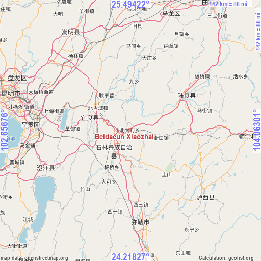
Beidacun Xiaozhai GPS coordinates[2]
24° 51' 28.404" North, 103° 21' 35.568" East
| Map corner | latitude | longitude |
|---|---|---|
| Upper-left | 25.49422°, | 102.65676° |
| Center: | 24.85789°, | 103.35988° |
| Lower-right: | 24.21827°, | 104.06301° |
| Map W x H: | 141.9×141.9 km | = 88.2×88.2mi |
| max Lat: | 53.31946° ⇑87% North |
| Beidacun Xiaozhai: | 24.85789° |
| min Lat: | ⇓13% South 18.22056° |
| min Long | Beidacun Xiaozh | max Long |
| 75.07348° | 103.35988° | 134.28917° |
| W 8.9%⇐ | ⇒91.1% E |
Elevation
Elevation of Beidacun Xiaozhai is 1833 m = 6014 ft, and this is 1348.2 m = 4423 ft above average elevation for this country.
| Max E: |
5622 m = 18445 ft | 6.2% |
| Beidacun Xiaozhai | 1833 m 6014 ft | |
| Avg. | 484.8 m = 1591 ft | |
Min E: |
-3 m = -10 ft | 93.8% |
See also: China elevation on elevation.city.
Geographical zone
Beidacun Xiaozhai is located in North temperate zone (between Tropic of Cancer and the Arctic Circle). Distance of this Northern Tropic circle is 158 km =98.2 mi to South.| Distance of | km | miles | from Beidacun Xiaozhai |
|---|---|---|---|
| North Pole | 7243.1 | 4500.7 | to North |
| Arctic Circle | 4637.2 | 2881.4 | to North |
| Tropic Cancer | 158 | 98.2 | to South |
| Equator | 2763.9 | 1717.4 | to South |


Nearby cities:
15 places around Beidacun Xiaozhai: (largest is in red/bold)
• Beigucheng
22.8 km =14.2 mi,  308°
308°
• Caodianjie
31.2 km =19.4 mi,  272°
272°
• Dake
29.6 km =18.4 mi,  204°
204°
• Goujie
23.3 km =14.5 mi,  250°
250°
• Huakoulongtan
40 km =24.9 mi,  172°
172°
• Kuangyuan
22.3 km =13.9 mi,  286°
286°
• Lufu
14.4 km =8.9 mi,  220°
220°
• Majie
21.6 km =13.4 mi,  208°
208°
• Nanyang
22.8 km =14.2 mi, 267°
• Shilin
5.2 km =3.2 mi, 212°
• Suyang
23.2 km =14.4 mi, 286°
• Tangchijie
34.9 km =21.7 mi, 289°
• Weize
17.3 km =10.7 mi,  164°
164°
• Yangzongnan Hengjie
39.6 km =24.6 mi,  264°
264°
• Zhongshu
35.9 km =22.3 mi,  58°
58°
Sources, notices
• [Note1] Compared only with cities in China existing in our database
• [Src1] Map data: © OpenStreetMap contributors (CC-BY-SA)
• [Src2] Other city data from geonames.org with taken over terms of usage.
• [Src3] Geographical zone / Annual Mean Temperature by Robert A. Rohde @ Wikipedia
