Zhongshu geodata
Zhongshu (Yunnan) is a seat of a third-order administrative division; located in China in Asia/Shanghai (GMT+8) time zone. In our database, there are 1268 cities with bigger population. Compared to other cities in China, 86.3% of cities are located further ↑North; 90.8% of cities are located further →East and 93.9% of cities have lower elevation than Zhongshu. Note1


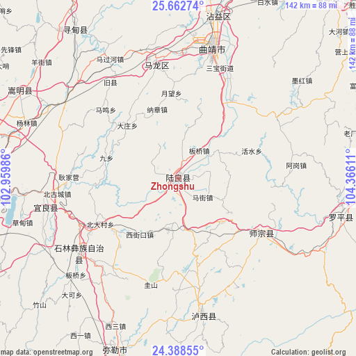
Zhongshu GPS coordinates[2]
25° 1' 38.28" North, 103° 39' 46.728" East
| Map corner | latitude | longitude |
|---|---|---|
| Upper-left | 25.66274°, | 102.95986° |
| Center: | 25.0273°, | 103.66298° |
| Lower-right: | 24.38855°, | 104.36611° |
| Map W x H: | 141.7×141.7 km | = 88×88mi |
| max Lat: | 53.31946° ⇑86.3% North |
| Zhongshu: | 25.0273° |
| min Lat: | ⇓13.7% South 18.22056° |
| min Long | Zhongshu | max Long |
| 75.07348° | 103.66298° | 134.28917° |
| W 9.2%⇐ | ⇒90.8% E |
Elevation
Elevation of Zhongshu is 1838 m = 6030 ft, and this is 1353.2 m = 4440 ft above average elevation for this country.
| Max E: |
5622 m = 18445 ft | 6.1% |
| Zhongshu | 1838 m 6030 ft | |
| Avg. | 484.8 m = 1591 ft | |
Min E: |
-3 m = -10 ft | 93.9% |
See also: China elevation on elevation.city.
Geographical zone
Zhongshu is located in North temperate zone (between Tropic of Cancer and the Arctic Circle). Distance of this Northern Tropic circle is 176.9 km =109.9 mi to South.| Distance of | km | miles | from Zhongshu |
|---|---|---|---|
| North Pole | 7224.3 | 4489 | to North |
| Arctic Circle | 4618.4 | 2869.7 | to North |
| Tropic Cancer | 176.9 | 109.9 | to South |
| Equator | 2782.8 | 1729.2 | to South |


Nearby cities:
15 places around Zhongshu: (largest is in red/bold)
• Beidacun Xiaozhai
35.9 km =22.3 mi,  238°
238°
• Beigucheng
48.7 km =30.3 mi,  264°
264°
• Danfeng
41.1 km =25.5 mi,  122°
122°
• Gaojiacun
47.8 km =29.7 mi,  57°
57°
• Kuangyuan
53.4 km =33.2 mi, 256°
• Lufu
49.8 km =30.9 mi,  233°
233°
• Majie
55.7 km =34.6 mi, 227°
• Nanyang
56.9 km =35.4 mi,  249°
249°
• Pingpo
45.5 km =28.3 mi,  11°
11°
• Qujing
52.1 km =32.4 mi, 13°
• Shilin
40.6 km =25.2 mi, 235°
• Suyang
54.2 km =33.7 mi, 256°
• Tongquan
42.6 km =26.5 mi,  346°
346°
• Weize
44 km =27.3 mi,  216°
216°
• Zhongshu
57.7 km =35.9 mi,  169°
169°
Sources, notices
• [Note1] Compared only with cities in China existing in our database
• [Src1] Map data: © OpenStreetMap contributors (CC-BY-SA)
• [Src2] Other city data from geonames.org with taken over terms of usage.
• [Src3] Geographical zone / Annual Mean Temperature by Robert A. Rohde @ Wikipedia
