Caohe geodata
Caohe (Gansu) is a seat of a fourth-order administrative division; located in China in Asia/Shanghai (GMT+8) time zone. In our database, there are 1268 cities with bigger population. Compared to other cities in China, 65.7% of cities are located further ↓South; 88.9% of cities are located further →East and 88.9% of cities have lower elevation than Caohe. Note1


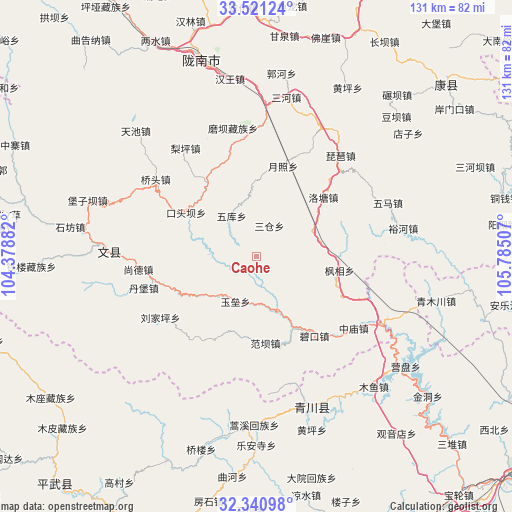
Caohe GPS coordinates[2]
32° 55' 59.088" North, 105° 4' 54.984" East
| Map corner | latitude | longitude |
|---|---|---|
| Upper-left | 33.52124°, | 104.37882° |
| Center: | 32.93308°, | 105.08194° |
| Lower-right: | 32.34098°, | 105.78507° |
| Map W x H: | 131.2×131.2 km | = 81.5×81.5mi |
| max Lat: | 53.31946° ⇑34.3% North |
| Caohe: | 32.93308° |
| min Lat: | ⇓65.7% South 18.22056° |
| min Long | Caohe | max Long |
| 75.07348° | 105.08194° | 134.28917° |
| W 11.1%⇐ | ⇒88.9% E |
Elevation
Elevation of Caohe is 1260 m = 4134 ft, and this is 775.2 m = 2543 ft above average elevation for this country.
| Max E: |
5622 m = 18445 ft | 11.1% |
| Caohe | 1260 m 4134 ft | |
| Avg. | 484.8 m = 1591 ft | |
Min E: |
-3 m = -10 ft | 88.9% |
See also: China elevation on elevation.city.
Geographical zone
Caohe is located in North temperate zone (between Tropic of Cancer and the Arctic Circle). Distance of this Northern Tropic circle is 1055.9 km =656.1 mi to South.| Distance of | km | miles | from Caohe |
|---|---|---|---|
| North Pole | 6345.2 | 3942.7 | to North |
| Arctic Circle | 3739.4 | 2323.6 | to North |
| Tropic Cancer | 1055.9 | 656.1 | to South |
| Equator | 3661.8 | 2275.3 | to South |


Nearby cities:
15 places around Caohe: (largest is in red/bold)
• Fengxiang
21.7 km =13.5 mi,  99°
99°
• Jianshan
23.6 km =14.7 mi,  296°
296°
• Koutouba
13.1 km =8.1 mi,  273°
273°
• Linjiang
20.7 km =12.9 mi,  313°
313°
• Luotang
22.7 km =14.1 mi,  48°
48°
• Pandi
13.2 km =8.2 mi, 45°
• Qiaotou
31.8 km =19.8 mi, 307°
• Sancang
9.5 km =5.9 mi,  19°
19°
• Shangde
29.3 km =18.2 mi,  264°
264°
• Sheshu
32.7 km =20.3 mi,  335°
335°
• Waina
30.5 km =19 mi,  354°
354°
• Weihe
23.7 km =14.7 mi,  73°
73°
• Wuku
12.4 km =7.7 mi,  329°
329°
• Xizhi
30.2 km =18.8 mi,  58°
58°
• Yuezhao
24.2 km =15 mi, 17°
Sources, notices
• [Note1] Compared only with cities in China existing in our database
• [Src1] Map data: © OpenStreetMap contributors (CC-BY-SA)
• [Src2] Other city data from geonames.org with taken over terms of usage.
• [Src3] Geographical zone / Annual Mean Temperature by Robert A. Rohde @ Wikipedia
