Pandi geodata
Pandi (Gansu) is a seat of a fourth-order administrative division; located in China in Asia/Shanghai (GMT+8) time zone. In our database, there are 1268 cities with bigger population. Compared to other cities in China, 66.2% of cities are located further ↓South; 88.8% of cities are located further →East and 88.5% of cities have lower elevation than Pandi. Note1


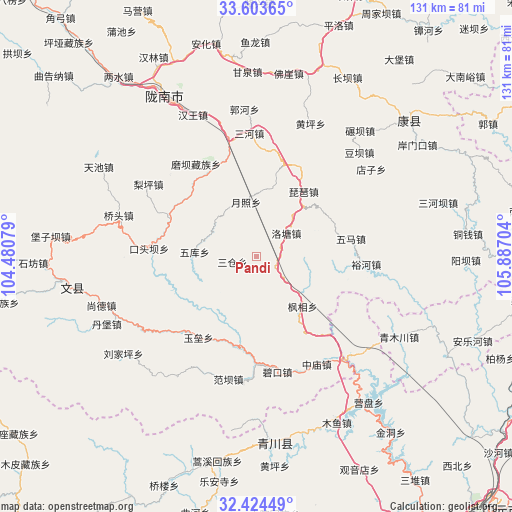
Pandi GPS coordinates[2]
33° 0' 57.744" North, 105° 11' 2.076" East
| Map corner | latitude | longitude |
|---|---|---|
| Upper-left | 33.60365°, | 104.48079° |
| Center: | 33.01604°, | 105.18391° |
| Lower-right: | 32.42449°, | 105.88704° |
| Map W x H: | 131.1×131.1 km | = 81.5×81.5mi |
| max Lat: | 53.31946° ⇑33.8% North |
| Pandi: | 33.01604° |
| min Lat: | ⇓66.2% South 18.22056° |
| min Long | Pandi | max Long |
| 75.07348° | 105.18391° | 134.28917° |
| W 11.2%⇐ | ⇒88.8% E |
Elevation
Elevation of Pandi is 1231 m = 4039 ft, and this is 746.2 m = 2448 ft above average elevation for this country.
| Max E: |
5622 m = 18445 ft | 11.5% |
| Pandi | 1231 m 4039 ft | |
| Avg. | 484.8 m = 1591 ft | |
Min E: |
-3 m = -10 ft | 88.5% |
See also: China elevation on elevation.city.
Geographical zone
Pandi is located in North temperate zone (between Tropic of Cancer and the Arctic Circle). Distance of this Northern Tropic circle is 1065.1 km =661.8 mi to South.| Distance of | km | miles | from Pandi |
|---|---|---|---|
| North Pole | 6336 | 3937 | to North |
| Arctic Circle | 3730.1 | 2317.8 | to North |
| Tropic Cancer | 1065.1 | 661.8 | to South |
| Equator | 3671 | 2281.1 | to South |


Nearby cities:
15 places around Pandi: (largest is in red/bold)
• Caohe
13.2 km =8.2 mi,  225°
225°
• Fengxiang
17.4 km =10.8 mi,  136°
136°
• Koutouba
24.1 km =15 mi,  249°
249°
• Linjiang
25 km =15.5 mi,  281°
281°
• Luotang
9.5 km =5.9 mi,  52°
52°
• Pipa
20.6 km =12.8 mi,  35°
35°
• Sancang
6.4 km =4 mi,  267°
267°
• Toufang
27.2 km =16.9 mi,  343°
343°
• Waina
24.6 km =15.3 mi,  329°
329°
• Weihe
13.3 km =8.3 mi,  100°
100°
• Wuku
15.9 km =9.9 mi, 275°
• Wuma
24.7 km =15.3 mi,  77°
77°
• Xizhi
17.4 km =10.8 mi,  67°
67°
• Yuezhao
14 km =8.7 mi,  351°
351°
• Yuhe
28.2 km =17.5 mi,  93°
93°
Sources, notices
• [Note1] Compared only with cities in China existing in our database
• [Src1] Map data: © OpenStreetMap contributors (CC-BY-SA)
• [Src2] Other city data from geonames.org with taken over terms of usage.
• [Src3] Geographical zone / Annual Mean Temperature by Robert A. Rohde @ Wikipedia
