Gongchangling geodata
Gongchangling (Liaoning) is a populated place; located in China in Asia/Shanghai (GMT+8) time zone. With population of 70,761 people, there are 608 cities with bigger population in this country. Compared to other cities in China, 89.4% of cities are located further ↓South; 93.2% of cities are located further ←West and 55.8% of cities have lower elevation than Gongchangling. Note1


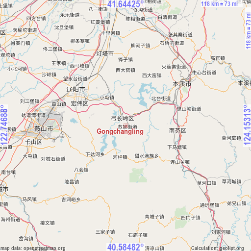
Gongchangling GPS coordinates[2]
41° 7' 0.012" North, 123° 27' 0" East
| Map corner | latitude | longitude |
|---|---|---|
| Upper-left | 41.64425°, | 122.74688° |
| Center: | 41.11667°, | 123.45° |
| Lower-right: | 40.58482°, | 124.15313° |
| Map W x H: | 117.8×117.8 km | = 73.2×73.2mi |
| max Lat: | 53.31946° ⇑10.6% North |
| Gongchangling: | 41.11667° |
| min Lat: | ⇓89.4% South 18.22056° |
| min Long | Gongchangling | max Long |
| 75.07348° | 123.45° | 134.28917° |
| W 93.2%⇐ | ⇒6.8% E |
Elevation
Elevation of Gongchangling is 214 m = 702 ft, and this is 270.8 m = 888 ft below average elevation for this country.
| Max E: |
5622 m = 18445 ft | 44.2% |
| Avg. | 484.8 m = 1591 ft | |
| Gongchangling | 214 m = 702 ft | |
Min E: |
-3 m = -10 ft | 55.8% |
See also: Gongchangling elevation on elevation.city.
Geographical zone
Gongchangling is located in North temperate zone (between Tropic of Cancer and the Arctic Circle). Distance of this Northern Tropic circle is 1965.8 km =1221.5 mi to South.| Distance of | km | miles | from Gongchangling |
|---|---|---|---|
| North Pole | 5435.3 | 3377.3 | to North |
| Arctic Circle | 2829.4 | 1758.1 | to North |
| Tropic Cancer | 1965.8 | 1221.5 | to South |
| Equator | 4571.7 | 2840.7 | to South |


Nearby cities:
15 places around Gongchangling: (largest is in red/bold)
• Anshan
38.5 km =23.9 mi,  271°
271°
• Bahui
29.3 km =18.2 mi,  225°
225°
• Benxi
32.6 km =20.3 mi,  54°
54°
• Caohekou
46.4 km =28.8 mi,  124°
124°
• Caohezhang
49.8 km =30.9 mi,  96°
96°
• Datun
47 km =29.2 mi,  253°
253°
• Fu’an
52.1 km =32.4 mi,  264°
264°
• Jiupu
42.3 km =26.3 mi, 262°
• Liaoyang
28.9 km =18 mi,  306°
306°
• Qingchengzi
44.9 km =27.9 mi,  163°
163°
• Sanjiazi
50.9 km =31.6 mi,  191°
191°
• Shangmatun
20.6 km =12.8 mi,  200°
200°
• Shimiaozi
51.4 km =31.9 mi,  173°
173°
• Simenzi
52.6 km =32.7 mi,  144°
144°
• Xiadahe
19.7 km =12.2 mi, 227°
Sources, notices
• [Note1] Compared only with cities in China existing in our database
• [Src1] Map data: © OpenStreetMap contributors (CC-BY-SA)
• [Src2] Other city data from geonames.org with taken over terms of usage.
• [Src3] Geographical zone / Annual Mean Temperature by Robert A. Rohde @ Wikipedia
