Shangmatun geodata
Shangmatun (Liaoning) is a seat of a fourth-order administrative division; located in China in Asia/Shanghai (GMT+8) time zone. In our database, there are 1268 cities with bigger population. Compared to other cities in China, 89.1% of cities are located further ↓South; 93.1% of cities are located further ←West and 51.9% of cities have higher elevation than Shangmatun. Note1


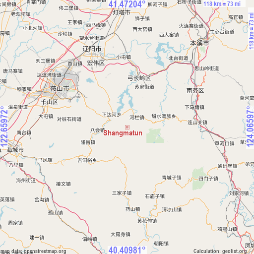
Shangmatun GPS coordinates[2]
40° 56' 35.016" North, 123° 21' 46.224" East
| Map corner | latitude | longitude |
|---|---|---|
| Upper-left | 41.47204°, | 122.65972° |
| Center: | 40.94306°, | 123.36284° |
| Lower-right: | 40.40981°, | 124.06597° |
| Map W x H: | 118.1×118.1 km | = 73.4×73.4mi |
| max Lat: | 53.31946° ⇑10.9% North |
| Shangmatun: | 40.94306° |
| min Lat: | ⇓89.1% South 18.22056° |
| min Long | Shangmatun | max Long |
| 75.07348° | 123.36284° | 134.28917° |
| W 93.1%⇐ | ⇒6.9% E |
Elevation
Elevation of Shangmatun is 150 m = 492 ft, and this is 334.8 m = 1098 ft below average elevation for this country.
| Max E: |
5622 m = 18445 ft | 51.9% |
| Avg. | 484.8 m = 1591 ft | |
| Shangmatun | 150 m = 492 ft | |
Min E: |
-3 m = -10 ft | 48.1% |
See also: China elevation on elevation.city.
Geographical zone
Shangmatun is located in North temperate zone (between Tropic of Cancer and the Arctic Circle). Distance of this Northern Tropic circle is 1946.5 km =1209.5 mi to South.| Distance of | km | miles | from Shangmatun |
|---|---|---|---|
| North Pole | 5454.6 | 3389.3 | to North |
| Arctic Circle | 2848.7 | 1770.1 | to North |
| Tropic Cancer | 1946.5 | 1209.5 | to South |
| Equator | 4552.4 | 2828.7 | to South |


Nearby cities:
15 places around Shangmatun: (largest is in red/bold)
• Anshan
37.2 km =23.1 mi,  302°
302°
• Bahui
13.7 km =8.5 mi,  264°
264°
• Datun
38.2 km =23.7 mi,  278°
278°
• Ganquan
42.8 km =26.6 mi,  273°
273°
• Gongchangling
20.6 km =12.8 mi,  20°
20°
• Jiewen
39.6 km =24.6 mi,  228°
228°
• Jiucaigou
39.2 km =24.4 mi,  178°
178°
• Jiupu
37.3 km =23.2 mi,  291°
291°
• Liaoyang
39.9 km =24.8 mi,  336°
336°
• Mafeng
40.9 km =25.4 mi,  248°
248°
• Muniu
33.7 km =20.9 mi,  200°
200°
• Qingchengzi
31.2 km =19.4 mi,  139°
139°
• Sanjiazi
30.7 km =19.1 mi, 184°
• Shimiaozi
34.3 km =21.3 mi,  158°
158°
• Xiadahe
9.6 km =6 mi,  309°
309°
Sources, notices
• [Note1] Compared only with cities in China existing in our database
• [Src1] Map data: © OpenStreetMap contributors (CC-BY-SA)
• [Src2] Other city data from geonames.org with taken over terms of usage.
• [Src3] Geographical zone / Annual Mean Temperature by Robert A. Rohde @ Wikipedia
