Cola geodata
Cola (Tibet) is a seat of a fourth-order administrative division; located in China in Asia/Shanghai (GMT+8) time zone. In our database, there are 1268 cities with bigger population. Compared to other cities in China, 55.4% of cities are located further ↓South; 96.6% of cities are located further →East and 99.9% of cities have lower elevation than Cola. Note1


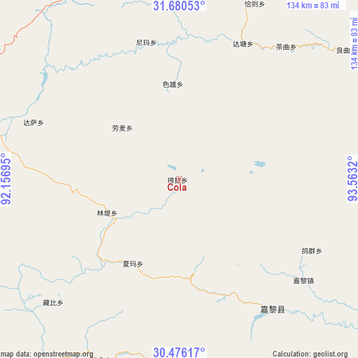
Cola GPS coordinates[2]
31° 4' 48.936" North, 92° 51' 36.252" East
| Map corner | latitude | longitude |
|---|---|---|
| Upper-left | 31.68053°, | 92.15695° |
| Center: | 31.08026°, | 92.86007° |
| Lower-right: | 30.47617°, | 93.5632° |
| Map W x H: | 133.9×133.9 km | = 83.2×83.2mi |
| max Lat: | 53.31946° ⇑44.6% North |
| Cola: | 31.08026° |
| min Lat: | ⇓55.4% South 18.22056° |
| min Long | Cola | max Long |
| 75.07348° | 92.86007° | 134.28917° |
| W 3.4%⇐ | ⇒96.6% E |
Elevation
Elevation of Cola is 4857 m = 15935 ft, and this is 4372.2 m = 14344 ft above average elevation for this country.
| Max E: |
5622 m = 18445 ft | 0.099999999999994% |
| Cola | 4857 m 15935 ft | |
| Avg. | 484.8 m = 1591 ft | |
Min E: |
-3 m = -10 ft | 99.9% |
See also: China elevation on elevation.city.
Geographical zone
Cola is located in North temperate zone (between Tropic of Cancer and the Arctic Circle). Distance of this Northern Tropic circle is 849.9 km =528.1 mi to South.| Distance of | km | miles | from Cola |
|---|---|---|---|
| North Pole | 6551.3 | 4070.8 | to North |
| Arctic Circle | 3945.4 | 2451.6 | to North |
| Tropic Cancer | 849.9 | 528.1 | to South |
| Equator | 3455.8 | 2147.3 | to South |


Nearby cities:
15 places around Cola: (largest is in red/bold)
• Arza
60.6 km =37.7 mi,  142°
142°
• Biruxong
79 km =49.1 mi,  63°
63°
• Caqu
63.7 km =39.6 mi,  38°
38°
• Codoi
78.7 km =48.9 mi,  212°
212°
• Dagsar
58.4 km =36.3 mi,  291°
291°
• Daqian
74.8 km =46.5 mi,  352°
352°
• Goqung
55.9 km =34.7 mi,  118°
118°
• Lhari
59 km =36.7 mi,  129°
129°
• Lingti
30.3 km =18.8 mi,  243°
243°
• Lomai
28.8 km =17.9 mi,  312°
312°
• Nyima
52.9 km =32.9 mi, 346°
• Qiaze
76 km =47.2 mi,  23°
23°
• Sexiong
35.7 km =22.2 mi,  356°
356°
• Xarma
35.7 km =22.2 mi, 208°
• Zangbi
65.9 km =40.9 mi,  225°
225°
Sources, notices
• [Note1] Compared only with cities in China existing in our database
• [Src1] Map data: © OpenStreetMap contributors (CC-BY-SA)
• [Src2] Other city data from geonames.org with taken over terms of usage.
• [Src3] Geographical zone / Annual Mean Temperature by Robert A. Rohde @ Wikipedia
