Da’ao geodata
Da’ao (Chongqing) is a seat of a fourth-order administrative division; located in China in Asia/Shanghai (GMT+8) time zone. In our database, there are 1268 cities with bigger population. Compared to other cities in China, 70.2% of cities are located further ↑North; 85.2% of cities are located further ←West and 68.4% of cities have lower elevation than Da’ao. Note1


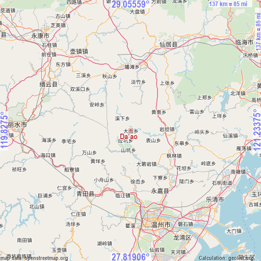
Da’ao GPS coordinates[2]
28° 26' 20.868" North, 120° 31' 50.232" East
| Map corner | latitude | longitude |
|---|---|---|
| Upper-left | 29.05559°, | 119.8275° |
| Center: | 28.43913°, | 120.53062° |
| Lower-right: | 27.81906°, | 121.23375° |
| Map W x H: | 137.5×137.5 km | = 85.4×85.4mi |
| max Lat: | 53.31946° ⇑70.2% North |
| Da’ao: | 28.43913° |
| min Lat: | ⇓29.8% South 18.22056° |
| min Long | Da’ao | max Long |
| 75.07348° | 120.53062° | 134.28917° |
| W 85.2%⇐ | ⇒14.8% E |
Elevation
Elevation of Da’ao is 384 m = 1260 ft, and this is 100.8 m = 331 ft below average elevation for this country.
| Max E: |
5622 m = 18445 ft | 31.6% |
| Avg. | 484.8 m = 1591 ft | |
| Da’ao | 384 m = 1260 ft | |
Min E: |
-3 m = -10 ft | 68.4% |
See also: China elevation on elevation.city.
Geographical zone
Da’ao is located in North temperate zone (between Tropic of Cancer and the Arctic Circle). Distance of this Northern Tropic circle is 556.2 km =345.6 mi to South.| Distance of | km | miles | from Da’ao |
|---|---|---|---|
| North Pole | 6844.9 | 4253.2 | to North |
| Arctic Circle | 4239 | 2634 | to North |
| Tropic Cancer | 556.2 | 345.6 | to South |
| Equator | 3162.1 | 1964.8 | to South |


Nearby cities:
15 places around Da’ao: (largest is in red/bold)
• Biaoshan
12.8 km =8 mi,  112°
112°
• Bilian
14.1 km =8.8 mi,  169°
169°
• Huangnan
17.8 km =11.1 mi,  55°
55°
• Jiekeng
12.4 km =7.7 mi,  274°
274°
• Ming’ao
17.5 km =10.9 mi,  182°
182°
• Muli
18.6 km =11.6 mi, 273°
• Pankeng
5.6 km =3.5 mi,  73°
73°
• Shankeng
10.1 km =6.3 mi,  187°
187°
• Shiran
15.5 km =9.6 mi,  230°
230°
• Xikou
18.3 km =11.4 mi,  92°
92°
• Xixia
8 km =5 mi,  326°
326°
• Xi’ao
13.7 km =8.5 mi,  262°
262°
• Xunzhai
11.2 km =7 mi,  205°
205°
• Yantan
19 km =11.8 mi, 87°
• Yingkeng
5.8 km =3.6 mi, 209°
Sources, notices
• [Note1] Compared only with cities in China existing in our database
• [Src1] Map data: © OpenStreetMap contributors (CC-BY-SA)
• [Src2] Other city data from geonames.org with taken over terms of usage.
• [Src3] Geographical zone / Annual Mean Temperature by Robert A. Rohde @ Wikipedia
