Pankeng geodata
Pankeng (Chongqing) is a seat of a fourth-order administrative division; located in China in Asia/Shanghai (GMT+8) time zone. In our database, there are 1268 cities with bigger population. Compared to other cities in China, 70.1% of cities are located further ↑North; 85.6% of cities are located further ←West and 54.5% of cities have lower elevation than Pankeng. Note1


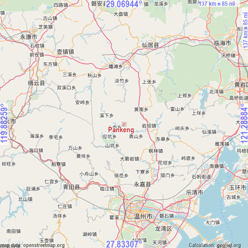
Pankeng GPS coordinates[2]
28° 27' 11.016" North, 120° 35' 8.556" East
| Map corner | latitude | longitude |
|---|---|---|
| Upper-left | 29.06944°, | 119.88259° |
| Center: | 28.45306°, | 120.58571° |
| Lower-right: | 27.83307°, | 121.28884° |
| Map W x H: | 137.5×137.5 km | = 85.4×85.4mi |
| max Lat: | 53.31946° ⇑70.1% North |
| Pankeng: | 28.45306° |
| min Lat: | ⇓29.9% South 18.22056° |
| min Long | Pankeng | max Long |
| 75.07348° | 120.58571° | 134.28917° |
| W 85.6%⇐ | ⇒14.4% E |
Elevation
Elevation of Pankeng is 201 m = 659 ft, and this is 283.8 m = 931 ft below average elevation for this country.
| Max E: |
5622 m = 18445 ft | 45.5% |
| Avg. | 484.8 m = 1591 ft | |
| Pankeng | 201 m = 659 ft | |
Min E: |
-3 m = -10 ft | 54.5% |
See also: China elevation on elevation.city.
Geographical zone
Pankeng is located in North temperate zone (between Tropic of Cancer and the Arctic Circle). Distance of this Northern Tropic circle is 557.8 km =346.6 mi to South.| Distance of | km | miles | from Pankeng |
|---|---|---|---|
| North Pole | 6843.4 | 4252.3 | to North |
| Arctic Circle | 4237.5 | 2633.1 | to North |
| Tropic Cancer | 557.8 | 346.6 | to South |
| Equator | 3163.7 | 1965.8 | to South |


Nearby cities:
15 places around Pankeng: (largest is in red/bold)
• Biaoshan
9.1 km =5.7 mi,  134°
134°
• Bilian
15.7 km =9.8 mi,  190°
190°
• Daruoyan
19.1 km =11.9 mi,  171°
171°
• Da’ao
5.6 km =3.5 mi,  253°
253°
• Huangnan
12.6 km =7.8 mi,  47°
47°
• Jiekeng
17.8 km =11.1 mi,  267°
267°
• Lixi
18.9 km =11.7 mi,  104°
104°
• Shankeng
13.4 km =8.3 mi,  209°
209°
• Xikou
13.1 km =8.1 mi, 100°
• Xixia
11.1 km =6.9 mi,  297°
297°
• Xunzhai
15.5 km =9.6 mi,  221°
221°
• Yantan
13.6 km =8.5 mi,  92°
92°
• Yantou
18.7 km =11.6 mi, 131°
• Yingkeng
10.5 km =6.5 mi,  231°
231°
• Zhangxi
18.9 km =11.7 mi,  79°
79°
Sources, notices
• [Note1] Compared only with cities in China existing in our database
• [Src1] Map data: © OpenStreetMap contributors (CC-BY-SA)
• [Src2] Other city data from geonames.org with taken over terms of usage.
• [Src3] Geographical zone / Annual Mean Temperature by Robert A. Rohde @ Wikipedia
