Dawu geodata
Dawu (Qinghai) is a seat of a fourth-order administrative division; located in China in Asia/Shanghai (GMT+8) time zone. In our database, there are 1268 cities with bigger population. Compared to other cities in China, 72.7% of cities are located further ↓South; 94.4% of cities are located further →East and 98.1% of cities have lower elevation than Dawu. Note1


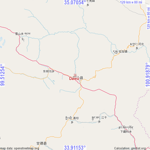
Dawu GPS coordinates[2]
34° 29' 34.98" North, 100° 12' 56.376" East
| Map corner | latitude | longitude |
|---|---|---|
| Upper-left | 35.07054°, | 99.51254° |
| Center: | 34.49305°, | 100.21566° |
| Lower-right: | 33.91153°, | 100.91879° |
| Map W x H: | 128.9×128.9 km | = 80.1×80.1mi |
| max Lat: | 53.31946° ⇑27.3% North |
| Dawu: | 34.49305° |
| min Lat: | ⇓72.7% South 18.22056° |
| min Long | Dawu | max Long |
| 75.07348° | 100.21566° | 134.28917° |
| W 5.6%⇐ | ⇒94.4% E |
Elevation
Elevation of Dawu is 3718 m = 12198 ft, and this is 3233.2 m = 10608 ft above average elevation for this country.
| Max E: |
5622 m = 18445 ft | 1.9% |
| Dawu | 3718 m 12198 ft | |
| Avg. | 484.8 m = 1591 ft | |
Min E: |
-3 m = -10 ft | 98.1% |
See also: China elevation on elevation.city.
Geographical zone
Dawu is located in North temperate zone (between Tropic of Cancer and the Arctic Circle). Distance of this Northern Tropic circle is 1229.3 km =763.9 mi to South.| Distance of | km | miles | from Dawu |
|---|---|---|---|
| North Pole | 6171.8 | 3835 | to North |
| Arctic Circle | 3565.9 | 2215.7 | to North |
| Tropic Cancer | 1229.3 | 763.9 | to South |
| Equator | 3835.3 | 2383.1 | to South |


Nearby cities:
15 places around Dawu: (largest is in red/bold)
• Bagou
88.3 km =54.9 mi,  10°
10°
• Dawu
3.3 km =2.1 mi,  156°
156°
• Dongqinggou
22.9 km =14.2 mi,  278°
278°
• Ganglong
81.3 km =50.5 mi,  177°
177°
• Gomang
80.7 km =50.1 mi,  18°
18°
• Gyangqai
40 km =24.9 mi,  154°
154°
• Kequ
65.1 km =40.5 mi,  206°
206°
• Kyinzhi
38.5 km =23.9 mi, 183°
• Oula Xiuma
87.5 km =54.4 mi,  108°
108°
• Tanggan
81.1 km =50.4 mi, 12°
• Xia Zanggor
64.9 km =40.3 mi,  136°
136°
• Xiagongma
77.7 km =48.3 mi, 183°
• Xiuma
63.4 km =39.4 mi, 9°
• Xueshan
55.9 km =34.7 mi,  306°
306°
• Zhongtie
83.9 km =52.1 mi,  354°
354°
Sources, notices
• [Note1] Compared only with cities in China existing in our database
• [Src1] Map data: © OpenStreetMap contributors (CC-BY-SA)
• [Src2] Other city data from geonames.org with taken over terms of usage.
• [Src3] Geographical zone / Annual Mean Temperature by Robert A. Rohde @ Wikipedia
