Dawu geodata
Dawu (Qinghai) is a seat of a third-order administrative division; located in China in Asia/Shanghai (GMT+8) time zone. In our database, there are 1268 cities with bigger population. Compared to other cities in China, 72.5% of cities are located further ↓South; 94.4% of cities are located further →East and 98.1% of cities have lower elevation than Dawu. Note1


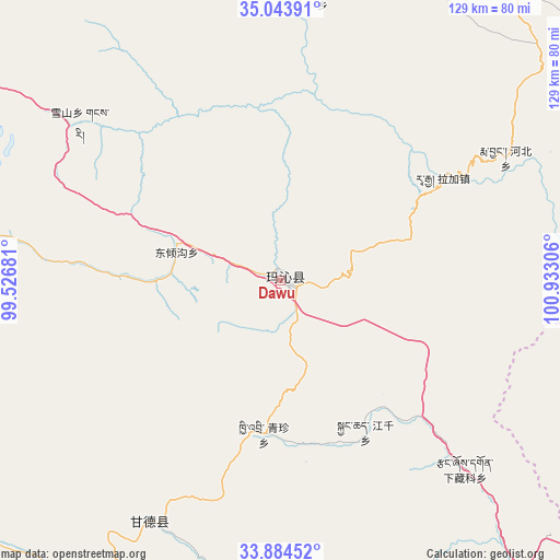
Dawu GPS coordinates[2]
34° 27' 58.428" North, 100° 13' 47.748" East
| Map corner | latitude | longitude |
|---|---|---|
| Upper-left | 35.04391°, | 99.52681° |
| Center: | 34.46623°, | 100.22993° |
| Lower-right: | 33.88452°, | 100.93306° |
| Map W x H: | 128.9×128.9 km | = 80.1×80.1mi |
| max Lat: | 53.31946° ⇑27.5% North |
| Dawu: | 34.46623° |
| min Lat: | ⇓72.5% South 18.22056° |
| min Long | Dawu | max Long |
| 75.07348° | 100.22993° | 134.28917° |
| W 5.6%⇐ | ⇒94.4% E |
Elevation
Elevation of Dawu is 3721 m = 12208 ft, and this is 3236.2 m = 10617 ft above average elevation for this country.
| Max E: |
5622 m = 18445 ft | 1.9% |
| Dawu | 3721 m 12208 ft | |
| Avg. | 484.8 m = 1591 ft | |
Min E: |
-3 m = -10 ft | 98.1% |
See also: China elevation on elevation.city.
Geographical zone
Dawu is located in North temperate zone (between Tropic of Cancer and the Arctic Circle). Distance of this Northern Tropic circle is 1226.4 km =762 mi to South.| Distance of | km | miles | from Dawu |
|---|---|---|---|
| North Pole | 6174.8 | 3836.8 | to North |
| Arctic Circle | 3568.9 | 2217.6 | to North |
| Tropic Cancer | 1226.4 | 762 | to South |
| Equator | 3832.3 | 2381.3 | to South |


Nearby cities:
15 places around Dawu: (largest is in red/bold)
• Dawu
3.3 km =2.1 mi,  336°
336°
• Dongqinggou
24.8 km =15.4 mi,  284°
284°
• Ganglong
78.3 km =48.7 mi,  178°
178°
• Gomang
83.1 km =51.6 mi,  16°
16°
• Gyangqai
36.8 km =22.9 mi,  154°
154°
• Kequ
63.1 km =39.2 mi,  208°
208°
• Kyinzhi
35.7 km =22.2 mi,  186°
186°
• Oula Xiuma
85.4 km =53.1 mi,  106°
106°
• Shanggongma
87.4 km =54.3 mi,  216°
216°
• Tanggan
83.7 km =52 mi,  11°
11°
• Xia Zanggor
61.8 km =38.4 mi,  135°
135°
• Xiagongma
74.8 km =46.5 mi, 184°
• Xiuma
66.2 km =41.1 mi, 8°
• Xueshan
58.8 km =36.5 mi,  308°
308°
• Zhongtie
87 km =54.1 mi,  354°
354°
Sources, notices
• [Note1] Compared only with cities in China existing in our database
• [Src1] Map data: © OpenStreetMap contributors (CC-BY-SA)
• [Src2] Other city data from geonames.org with taken over terms of usage.
• [Src3] Geographical zone / Annual Mean Temperature by Robert A. Rohde @ Wikipedia
