Gyangqai geodata
Gyangqai (Qinghai) is a seat of a fourth-order administrative division; located in China in Asia/Shanghai (GMT+8) time zone. In our database, there are 1268 cities with bigger population. Compared to other cities in China, 70.9% of cities are located further ↓South; 94.2% of cities are located further →East and 98.9% of cities have lower elevation than Gyangqai. Note1


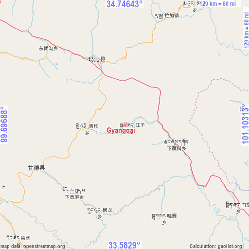
Gyangqai GPS coordinates[2]
34° 10' 0.012" North, 100° 24' 0" East
| Map corner | latitude | longitude |
|---|---|---|
| Upper-left | 34.74643°, | 99.69688° |
| Center: | 34.16667°, | 100.4° |
| Lower-right: | 33.5829°, | 101.10313° |
| Map W x H: | 129.4×129.4 km | = 80.4×80.4mi |
| max Lat: | 53.31946° ⇑29.1% North |
| Gyangqai: | 34.16667° |
| min Lat: | ⇓70.9% South 18.22056° |
| min Long | Gyangqai | max Long |
| 75.07348° | 100.4° | 134.28917° |
| W 5.8%⇐ | ⇒94.2% E |
Elevation
Elevation of Gyangqai is 4120 m = 13517 ft, and this is 3635.2 m = 11927 ft above average elevation for this country.
| Max E: |
5622 m = 18445 ft | 1.1% |
| Gyangqai | 4120 m 13517 ft | |
| Avg. | 484.8 m = 1591 ft | |
Min E: |
-3 m = -10 ft | 98.9% |
See also: China elevation on elevation.city.
Geographical zone
Gyangqai is located in North temperate zone (between Tropic of Cancer and the Arctic Circle). Distance of this Northern Tropic circle is 1193.1 km =741.4 mi to South.| Distance of | km | miles | from Gyangqai |
|---|---|---|---|
| North Pole | 6208.1 | 3857.5 | to North |
| Arctic Circle | 3602.2 | 2238.3 | to North |
| Tropic Cancer | 1193.1 | 741.4 | to South |
| Equator | 3799 | 2360.6 | to South |


Nearby cities:
15 places around Gyangqai: (largest is in red/bold)
• Basar
51.6 km =32.1 mi,  159°
159°
• Dawu
36.8 km =22.9 mi,  334°
334°
• Dawu
40 km =24.9 mi, 334°
• Dongqinggou
56.1 km =34.9 mi,  315°
315°
• Dêrnang
84.3 km =52.4 mi,  194°
194°
• Ganglong
46.9 km =29.1 mi,  196°
196°
• Jimai
83.3 km =51.8 mi,  236°
236°
• Kequ
51 km =31.7 mi, 244°
• Kyinzhi
19.6 km =12.2 mi,  263°
263°
• Mintang
71.2 km =44.2 mi,  124°
124°
• Oula Xiuma
66.7 km =41.4 mi,  82°
82°
• Shanggongma
77.1 km =47.9 mi, 241°
• Wosai
82.5 km =51.3 mi,  222°
222°
• Xia Zanggor
29.6 km =18.4 mi,  111°
111°
• Xiagongma
46.5 km =28.9 mi,  207°
207°
Sources, notices
• [Note1] Compared only with cities in China existing in our database
• [Src1] Map data: © OpenStreetMap contributors (CC-BY-SA)
• [Src2] Other city data from geonames.org with taken over terms of usage.
• [Src3] Geographical zone / Annual Mean Temperature by Robert A. Rohde @ Wikipedia
