Bacun geodata
Bacun (Tibet) is a seat of a fourth-order administrative division; located in China in Asia/Shanghai (GMT+8) time zone. In our database, there are 1268 cities with bigger population. Compared to other cities in China, 59.9% of cities are located further ↑North; 96.6% of cities are located further →East and 99% of cities have lower elevation than Bacun. Note1


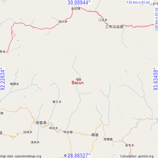
Bacun GPS coordinates[2]
29° 28' 45.12" North, 92° 55' 53.256" East
| Map corner | latitude | longitude |
|---|---|---|
| Upper-left | 30.08944°, | 92.22834° |
| Center: | 29.4792°, | 92.93146° |
| Lower-right: | 28.86527°, | 93.63459° |
| Map W x H: | 136.1×136.1 km | = 84.6×84.6mi |
| max Lat: | 53.31946° ⇑59.9% North |
| Bacun: | 29.4792° |
| min Lat: | ⇓40.1% South 18.22056° |
| min Long | Bacun | max Long |
| 75.07348° | 92.93146° | 134.28917° |
| W 3.4%⇐ | ⇒96.6% E |
Elevation
Elevation of Bacun is 4193 m = 13757 ft, and this is 3708.2 m = 12166 ft above average elevation for this country.
| Max E: |
5622 m = 18445 ft | 1% |
| Bacun | 4193 m 13757 ft | |
| Avg. | 484.8 m = 1591 ft | |
Min E: |
-3 m = -10 ft | 99% |
See also: China elevation on elevation.city.
Geographical zone
Bacun is located in North temperate zone (between Tropic of Cancer and the Arctic Circle). Distance of this Northern Tropic circle is 671.9 km =417.5 mi to South.| Distance of | km | miles | from Bacun |
|---|---|---|---|
| North Pole | 6729.3 | 4181.4 | to North |
| Arctic Circle | 4123.4 | 2562.2 | to North |
| Tropic Cancer | 671.9 | 417.5 | to South |
| Equator | 3277.8 | 2036.7 | to South |


Nearby cities:
15 places around Bacun: (largest is in red/bold)
• Baiba
95.9 km =59.6 mi,  68°
68°
• Cuijiu
21.6 km =13.4 mi,  260°
260°
• Dengmu
66.4 km =41.3 mi,  188°
188°
• Jindong
71.5 km =44.4 mi,  142°
142°
• Laduo
54.7 km =34 mi,  164°
164°
• Lang
49.5 km =30.8 mi,  174°
174°
• Nangxian
50.4 km =31.3 mi, 162°
• Ngarrab
49.8 km =30.9 mi,  221°
221°
• Norbusa
76.4 km =47.5 mi,  247°
247°
• Orong
85.8 km =53.3 mi,  117°
117°
• Rinang
61.1 km =38 mi,  210°
210°
• Tunggar
58.1 km =36.1 mi,  154°
154°
• Xarlung
58.8 km =36.5 mi,  37°
37°
• Zari
99.2 km =61.6 mi, 154°
• Zhomda
46.5 km =28.9 mi, 192°
Sources, notices
• [Note1] Compared only with cities in China existing in our database
• [Src1] Map data: © OpenStreetMap contributors (CC-BY-SA)
• [Src2] Other city data from geonames.org with taken over terms of usage.
• [Src3] Geographical zone / Annual Mean Temperature by Robert A. Rohde @ Wikipedia
