Norbusa geodata
Norbusa (Tibet) is a seat of a fourth-order administrative division; located in China in Asia/Shanghai (GMT+8) time zone. In our database, there are 1268 cities with bigger population. Compared to other cities in China, 63% of cities are located further ↑North; 96.8% of cities are located further →East and 99% of cities have lower elevation than Norbusa. Note1


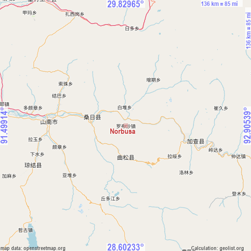
Norbusa GPS coordinates[2]
29° 13' 4.188" North, 92° 12' 8.136" East
| Map corner | latitude | longitude |
|---|---|---|
| Upper-left | 29.82965°, | 91.49914° |
| Center: | 29.21783°, | 92.20226° |
| Lower-right: | 28.60233°, | 92.90539° |
| Map W x H: | 136.5×136.5 km | = 84.8×84.8mi |
| max Lat: | 53.31946° ⇑63% North |
| Norbusa: | 29.21783° |
| min Lat: | ⇓37% South 18.22056° |
| min Long | Norbusa | max Long |
| 75.07348° | 92.20226° | 134.28917° |
| W 3.2%⇐ | ⇒96.8% E |
Elevation
Elevation of Norbusa is 4211 m = 13816 ft, and this is 3726.2 m = 12225 ft above average elevation for this country.
| Max E: |
5622 m = 18445 ft | 1% |
| Norbusa | 4211 m 13816 ft | |
| Avg. | 484.8 m = 1591 ft | |
Min E: |
-3 m = -10 ft | 99% |
See also: China elevation on elevation.city.
Geographical zone
Norbusa is located in North temperate zone (between Tropic of Cancer and the Arctic Circle). Distance of this Northern Tropic circle is 642.8 km =399.4 mi to South.| Distance of | km | miles | from Norbusa |
|---|---|---|---|
| North Pole | 6758.3 | 4199.4 | to North |
| Arctic Circle | 4152.5 | 2580.2 | to North |
| Tropic Cancer | 642.8 | 399.4 | to South |
| Equator | 3248.7 | 2018.6 | to South |


Nearby cities:
15 places around Norbusa: (largest is in red/bold)
• Bacun
76.4 km =47.5 mi,  67°
67°
• Changzhug
41.8 km =26 mi,  266°
266°
• Chaqi
77.7 km =48.3 mi, 272°
• Cuijiu
55.6 km =34.5 mi,  62°
62°
• Dengmu
71.7 km =44.6 mi,  120°
120°
• Dopozhang
51.4 km =31.9 mi,  282°
282°
• Lang
78.1 km =48.5 mi,  105°
105°
• Layu
53.4 km =33.2 mi,  261°
261°
• Naidong
41.8 km =26 mi, 273°
• Nangxian
88.1 km =54.7 mi,  102°
102°
• Ngarrab
38.5 km =23.9 mi, 102°
• Pozhang
37.6 km =23.4 mi,  252°
252°
• Rinang
45.8 km =28.5 mi, 120°
• Sozhug
39.3 km =24.4 mi,  305°
305°
• Zhomda
63.3 km =39.3 mi, 105°
Sources, notices
• [Note1] Compared only with cities in China existing in our database
• [Src1] Map data: © OpenStreetMap contributors (CC-BY-SA)
• [Src2] Other city data from geonames.org with taken over terms of usage.
• [Src3] Geographical zone / Annual Mean Temperature by Robert A. Rohde @ Wikipedia
