Guangrong geodata
Guangrong (Heilongjiang) is a seat of a fourth-order administrative division; located in China in Asia/Shanghai (GMT+8) time zone. In our database, there are 1268 cities with bigger population. Compared to other cities in China, 97.6% of cities are located further ↓South; 95.9% of cities are located further ←West and 55.6% of cities have lower elevation than Guangrong. Note1


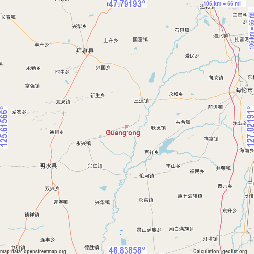
Guangrong GPS coordinates[2]
47° 19' 2.676" North, 126° 19' 7.608" East
| Map corner | latitude | longitude |
|---|---|---|
| Upper-left | 47.79193°, | 125.61566° |
| Center: | 47.31741°, | 126.31878° |
| Lower-right: | 46.83858°, | 127.02191° |
| Map W x H: | 106×106 km | = 65.9×65.9mi |
| max Lat: | 53.31946° ⇑2.4% North |
| Guangrong: | 47.31741° |
| min Lat: | ⇓97.6% South 18.22056° |
| min Long | Guangrong | max Long |
| 75.07348° | 126.31878° | 134.28917° |
| W 95.9%⇐ | ⇒4.1% E |
Elevation
Elevation of Guangrong is 212 m = 696 ft, and this is 272.8 m = 895 ft below average elevation for this country.
| Max E: |
5622 m = 18445 ft | 44.4% |
| Avg. | 484.8 m = 1591 ft | |
| Guangrong | 212 m = 696 ft | |
Min E: |
-3 m = -10 ft | 55.6% |
See also: China elevation on elevation.city.
Geographical zone
Guangrong is located in North temperate zone (between Tropic of Cancer and the Arctic Circle). Distance of this North polar circle is 2140 km =1329.7 mi to North.| Distance of | km | miles | from Guangrong |
|---|---|---|---|
| North Pole | 4745.9 | 2949 | to North |
| Arctic Circle | 2140 | 1329.7 | to North |
| Tropic Cancer | 2655.3 | 1649.9 | to South |
| Equator | 5261.2 | 3269.2 | to South |


Nearby cities:
15 places around Guangrong: (largest is in red/bold)
• Baixiang
14.6 km =9.1 mi,  136°
136°
• Fanrong
5.9 km =3.7 mi,  255°
255°
• Fengshan
25.3 km =15.7 mi,  129°
129°
• Gonghe
23.4 km =14.5 mi,  83°
83°
• Huaguang
24.1 km =15 mi,  18°
18°
• Lianfa
12.9 km =8 mi,  89°
89°
• Lunhe
21.6 km =13.4 mi,  157°
157°
• Sandao
12.7 km =7.9 mi,  28°
28°
• Shuren
18.9 km =11.7 mi,  203°
203°
• Xingguo
26.9 km =16.7 mi,  337°
337°
• Xingquan
27.7 km =17.2 mi,  282°
282°
• Xingren
20.7 km =12.9 mi,  220°
220°
• Xinsheng
18.2 km =11.3 mi,  317°
317°
• Yonghe
24.7 km =15.3 mi,  55°
55°
• Yongxing
19.3 km =12 mi,  250°
250°
Sources, notices
• [Note1] Compared only with cities in China existing in our database
• [Src1] Map data: © OpenStreetMap contributors (CC-BY-SA)
• [Src2] Other city data from geonames.org with taken over terms of usage.
• [Src3] Geographical zone / Annual Mean Temperature by Robert A. Rohde @ Wikipedia
