Dianya geodata
Dianya (Hubei) is a seat of a fourth-order administrative division; located in China in Asia/Shanghai (GMT+8) time zone. In our database, there are 1268 cities with bigger population. Compared to other cities in China, 57.7% of cities are located further ↓South; 65.8% of cities are located further →East and 77.9% of cities have lower elevation than Dianya. Note1


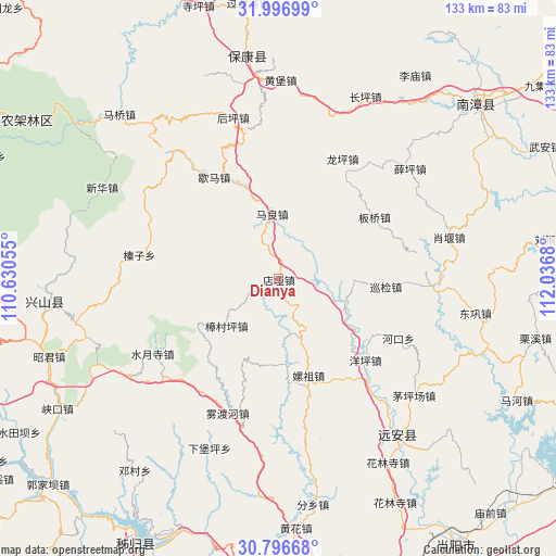
Dianya GPS coordinates[2]
31° 23' 55.5" North, 111° 20' 1.212" East
| Map corner | latitude | longitude |
|---|---|---|
| Upper-left | 31.99699°, | 110.63055° |
| Center: | 31.39875°, | 111.33367° |
| Lower-right: | 30.79668°, | 112.0368° |
| Map W x H: | 133.5×133.5 km | = 83×83mi |
| max Lat: | 53.31946° ⇑42.3% North |
| Dianya: | 31.39875° |
| min Lat: | ⇓57.7% South 18.22056° |
| min Long | Dianya | max Long |
| 75.07348° | 111.33367° | 134.28917° |
| W 34.2%⇐ | ⇒65.8% E |
Elevation
Elevation of Dianya is 611 m = 2005 ft, and this is 126.2 m = 414 ft above average elevation for this country.
| Max E: |
5622 m = 18445 ft | 22.1% |
| Dianya | 611 m 2005 ft | |
| Avg. | 484.8 m = 1591 ft | |
Min E: |
-3 m = -10 ft | 77.9% |
See also: China elevation on elevation.city.
Geographical zone
Dianya is located in North temperate zone (between Tropic of Cancer and the Arctic Circle). Distance of this Northern Tropic circle is 885.3 km =550.1 mi to South.| Distance of | km | miles | from Dianya |
|---|---|---|---|
| North Pole | 6515.8 | 4048.7 | to North |
| Arctic Circle | 3910 | 2429.6 | to North |
| Tropic Cancer | 885.3 | 550.1 | to South |
| Equator | 3491.2 | 2169.3 | to South |


Nearby cities:
15 places around Dianya: (largest is in red/bold)
• Banqiao
28 km =17.4 mi,  58°
58°
• Hehua
24 km =14.9 mi,  162°
162°
• Hekou
32.2 km =20 mi,  116°
116°
• Houping
39.8 km =24.7 mi,  344°
344°
• Jiuxian
40.4 km =25.1 mi,  139°
139°
• Longping
32.6 km =20.3 mi,  28°
28°
• Maliang
15.6 km =9.7 mi,  354°
354°
• Shuiyuesi
35.2 km =21.9 mi,  239°
239°
• Wuduhe
34.5 km =21.4 mi,  200°
200°
• Xiema
28.8 km =17.9 mi,  327°
327°
• Xueping
41.2 km =25.6 mi,  50°
50°
• Xunjian
26.4 km =16.4 mi,  93°
93°
• Yangping
28.5 km =17.7 mi,  132°
132°
• Zhangcunping
16.6 km =10.3 mi,  227°
227°
• Zhenzi
34.2 km =21.3 mi,  279°
279°
Sources, notices
• [Note1] Compared only with cities in China existing in our database
• [Src1] Map data: © OpenStreetMap contributors (CC-BY-SA)
• [Src2] Other city data from geonames.org with taken over terms of usage.
• [Src3] Geographical zone / Annual Mean Temperature by Robert A. Rohde @ Wikipedia
